
The short version: the United States is preparing to replace NAD 83 and NAVD 88 with a modernized National Spatial Reference System built around GNSS, gravity, plate-fixed reference frames, and time-dependent coordinates. The names say “2022,” but that is a family name—not the release year.
Status check — September 2026
NAD 83 and NAVD 88 remain the official datums today. NOAA’s National Geodetic Survey (NGS) has released modernized NSRS components as beta products for public testing. NGS says beta testing will continue until at least March 2027. Treat beta output as test data, not as an automatic replacement for contract, statutory, or agency requirements.
There is also a practical deadline: NGS says projects that create or update control in the current NSRS through OPUS Projects or differential leveling must be submitted by January 13, 2027.
First, what is actually changing?
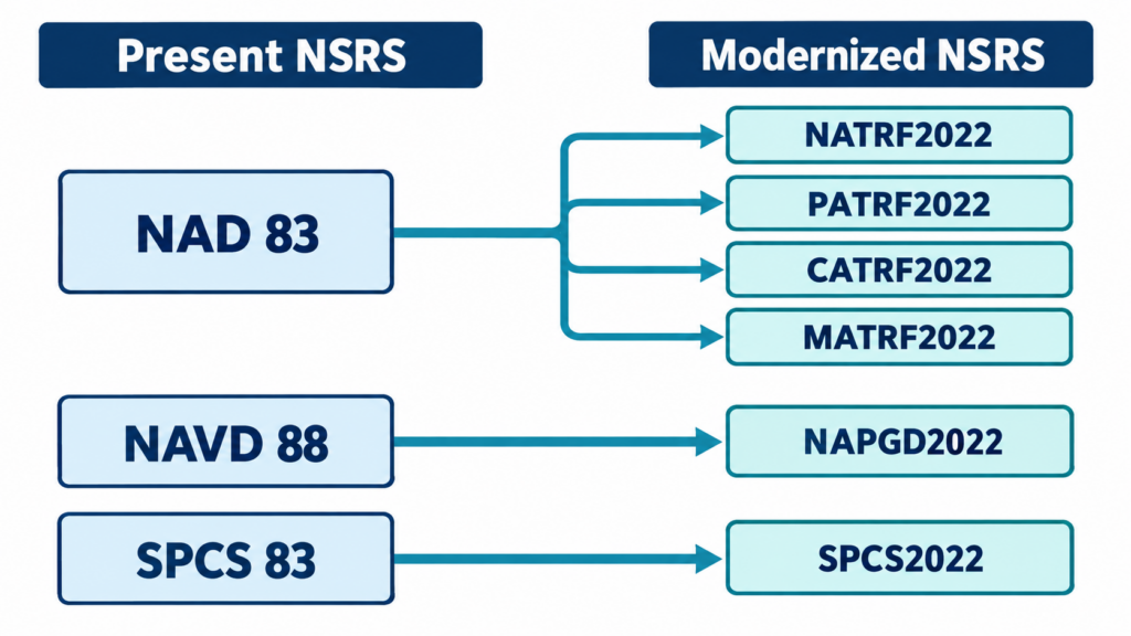
The modernized NSRS is not one new horizontal datum plus one new vertical datum in the old sense. NGS describes it as four terrestrial reference frames for geometric coordinates and one geopotential datum for gravity-related heights.
| Today | Modernized NSRS | What it controls |
|---|---|---|
| NAD 83 | NATRF2022 | Latitude, longitude, and ellipsoid height on the North American plate |
| NAD 83 | PATRF2022 | Geometric coordinates on the Pacific plate |
| NAD 83 | CATRF2022 | Geometric coordinates on the Caribbean plate |
| NAD 83 | MATRF2022 | Geometric coordinates on the Mariana plate |
| NAVD 88 and other vertical datums | NAPGD2022 | Orthometric heights and other geopotential quantities derived from gravity models |
| SPCS 83 | SPCS2022 | Projected northing and easting coordinates tied to the applicable 2022 frame |
For surveyors in Florida, the geometric frame of primary interest will be NATRF2022. State Plane users will also need to understand Florida’s SPCS2022 zones, parameters, units, and distortion characteristics rather than assuming an old Florida East, West, or North setup can simply be relabeled.
Why replace systems that already work?
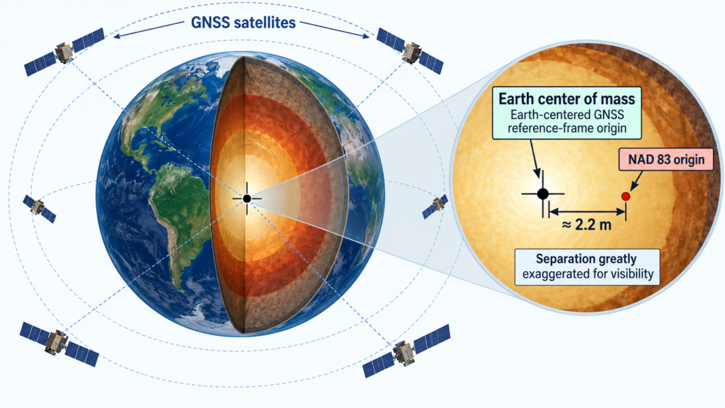
- NAD 83 is not geocentric. NGS reports that its origin is displaced from the best modern estimate of Earth’s center of mass by about 2.2 meters.
- NAVD 88 contains systematic error. NGS describes it as biased by roughly half a meter and tilted by about one meter from coast to coast relative to modern global geoid models.
- Passive marks do not stand still forever. Bench marks and control monuments can move, subside, heave, be disturbed, or disappear while their published values remain in circulation.
- GNSS is naturally Earth-centered. A geocentric NSRS aligns national work more directly with GNSS and international terrestrial reference frames.
- Gravity lets NGS improve height access. NAPGD2022 is realized through a gravimetric geoid model rather than being defined by a continent-spanning leveling network.
A coordinate changing does not mean the monument moved. Often the number changes because the reference system changed. Think of measuring the same point from a different, better-defined origin.
The vertical change: from a leveling datum to a gravity-based datum
Entry-level surveyors should keep three quantities separate:
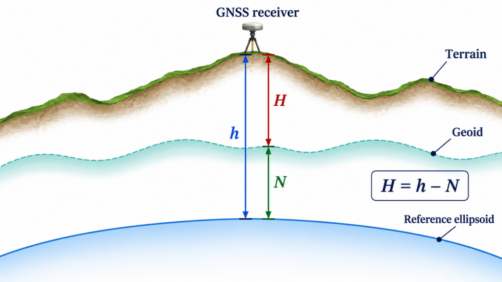
- Ellipsoid height (h): the height above or below the reference ellipsoid, commonly obtained from GNSS processing.
- Geoid height or undulation (N): the separation between the ellipsoid and the geoid model.
- Orthometric height (H): the practical “elevation” referenced to the geopotential datum.
H = h − N
Under NAPGD2022, GNSS supplies the ellipsoid height and GEOID2022 supplies the modeled separation needed to obtain an orthometric height. That does not make leveling obsolete: differential leveling remains valuable for transferring height locally, construction control, deformation monitoring, and checking project networks. What changes is the national vertical datum’s foundation and the primary way surveyors access it.
The part beginners often miss: coordinates now need a date
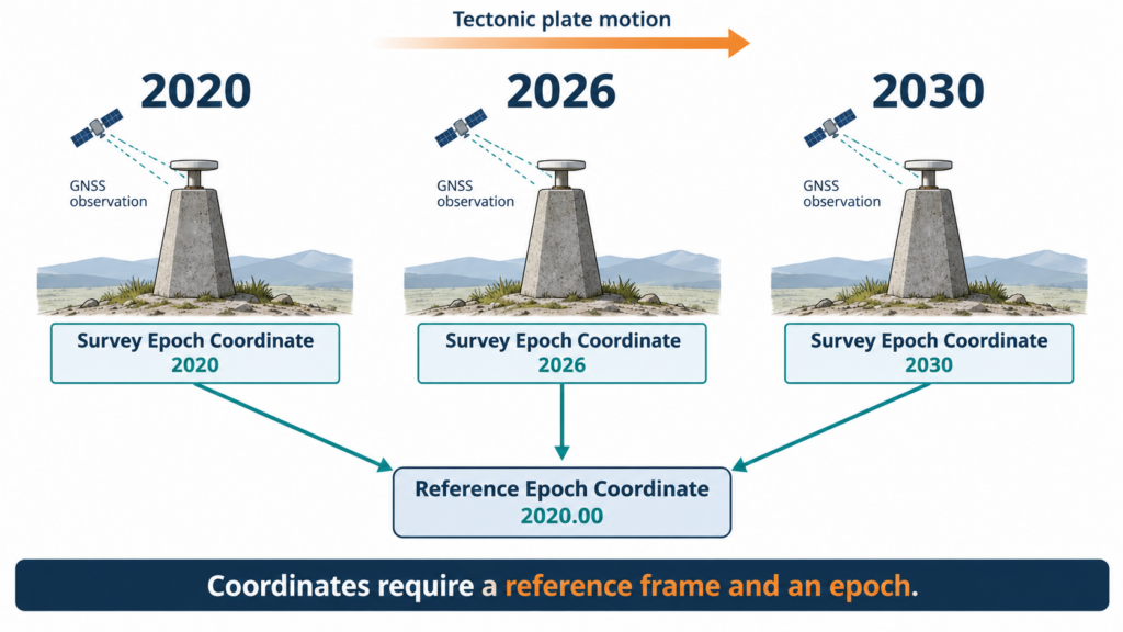
The Earth moves. Tectonic plates rotate, the crust deforms, and local ground can subside. In the modernized NSRS, a precise coordinate without an epoch is incomplete.
| Term | Plain-language meaning |
|---|---|
| Survey Epoch Coordinate (SEC) | A coordinate associated with the date when observations were made. |
| Reference Epoch Coordinate (REC) | A coordinate estimated at a standard reference date so points can be compared consistently. NGS plans the first reference epoch as 2020.00. |
| Velocity model | A model used to account for motion through time within a reference frame. |
The plate-fixed frames reduce apparent coordinate change on the stable portions of their named plates, but they do not eliminate real movement or deformation. Record the frame, epoch, coordinate type, units, projection, geoid model, equipment, antenna height method, processing software, and control used.
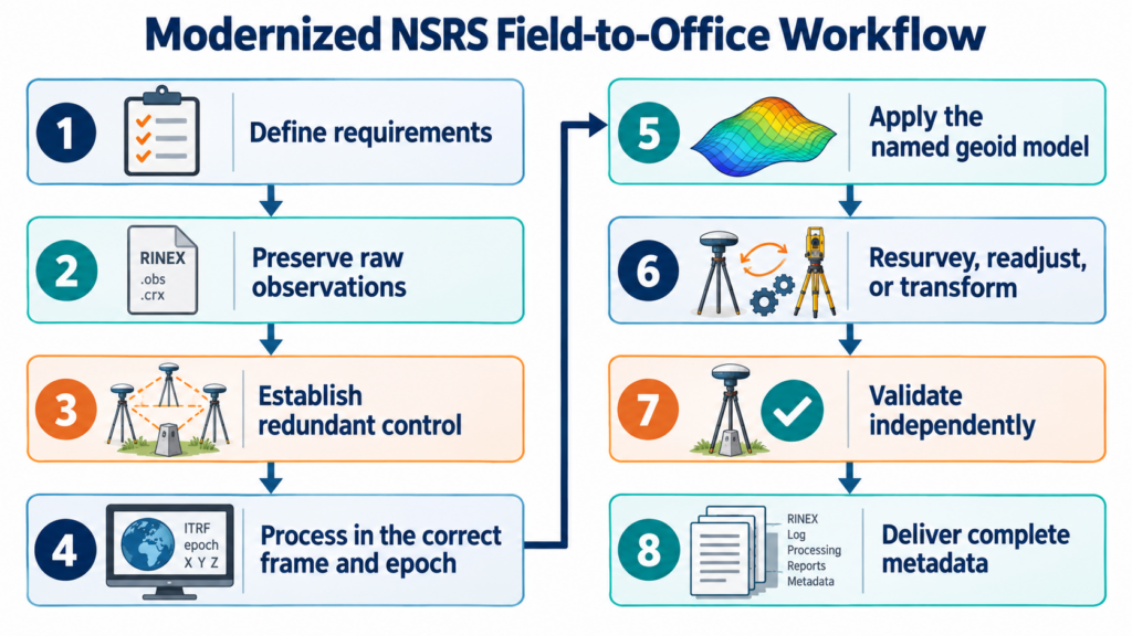
A practical field-to-office workflow
1. Read the scope before touching the equipment
Identify the required horizontal frame, vertical datum, epoch, projection, zone, unit, accuracy class, and deliverable format. If the contract simply says “State Plane” or “NAVD,” get clarification. Never infer a datum from the size of the numbers.
2. Preserve the raw evidence
Keep raw GNSS observations, receiver and antenna metadata, field notes, level runs, calibration records, control descriptions, adjustment files, and software reports. NGS explicitly recommends saving original observations and complete metadata because readjustment is generally stronger than transforming final coordinates alone.
3. Establish control with redundancy
Use appropriate NOAA CORS Network ties, independent observations, sensible geometry, and checks on stable passive marks. A published value is evidence—not permission to skip reconnaissance and verification.
4. Process in the correct frame and epoch
Use the applicable official or beta NGS tools for the purpose at hand. During the beta period, label every beta result unmistakably and keep it out of production deliverables unless the governing authority expressly accepts it.
5. Compute heights with the named geoid model
Do not report an orthometric height derived from GNSS without naming the geopotential datum and geoid model. A bare elevation number is not self-defining.
6. Choose the right migration method
NGS describes three paths for legacy data:
- Resurvey when the required accuracy, risk, or condition of the original control warrants new observations.
- Readjust when original observations and metadata are available. Reprocessing the measurements against new control preserves more information.
- Transform when only finished coordinates remain or when the project’s accuracy requirements allow a modeled conversion.
7. Validate before delivery
Check independent control, closures, residuals, scale factors, convergence, combined factor, units, and sample transformations. Compare old and new values, but do not expect them to match numerically. Document why they differ.
8. Deliver metadata with the coordinates
At minimum, state the reference frame or datum, epoch, SEC or REC status, SPCS2022 zone, linear unit, geoid model, transformation or adjustment method, software and version, control basis, and estimated accuracy.
Florida considerations
- Florida work often carries unusually high consequences for small vertical mistakes because flood studies, drainage, coastal construction, and sea-level monitoring depend on reliable elevations.
- Verify which Florida SPCS2022 zone or layer the client or agency requires. SPCS2022 can include statewide and multi-zone layers, and NGS publishes exact definitions and distortion maps.
- SPCS2022 tables use the international foot where values are expressed in feet. Do not silently treat those values as U.S. survey feet.
- Check Florida statutes, administrative rules, agency manuals, and contract language before adopting the new system on a production survey. Federal adoption does not automatically rewrite every state or local requirement.
- Be especially careful when mixing legacy GIS, FEMA products, county control, RTN output, design files, and new NSRS coordinates. A plausible-looking overlay can still conceal a datum, epoch, unit, or projection mismatch.
Common mistakes to avoid
- Calling NATRF2022 simply “NAD 2022.”
- Assuming the “2022” name means the system became official in 2022.
- Publishing a coordinate without its frame, epoch, zone, and unit.
- Treating ellipsoid height as elevation.
- Relabeling legacy coordinates instead of transforming, readjusting, or resurveying them.
- Mixing international feet and U.S. survey feet.
- Using beta results in production without explicit authorization and documentation.
What an entry-level surveyor should do now
- Learn the difference between a datum, a reference frame, a projection, a geoid model, and an epoch.
- Practice with NGS beta tools using copied datasets—not live production files.
- Inventory old projects: which still have raw observations, control ties, field notes, and adjustment files?
- Update field and CAD/GIS templates so datum, frame, epoch, zone, unit, geoid, and source are mandatory fields.
- Build a small local test project and compare resurvey, readjustment, and transformation results.
- Follow NGS announcements and software/vendor updates; do not assume every data collector, RTN, CAD package, GIS, and localization file will switch at the same time.
The takeaway
The modernized NSRS is less about memorizing five new acronyms and more about changing habits. Coordinates must carry time and metadata. National height access moves toward GNSS plus gravity. Raw observations become even more valuable. And the surveyor’s professional judgment—choosing whether to resurvey, readjust, or transform—remains central.
The monuments are not becoming meaningless. They are becoming evidence inside a more dynamic, measurable, and maintainable reference system.
Authoritative references and tools
- NGS: New Datums—Replacing NAVD 88 and NAD 83
- NGS: NSRS Modernization Timeline
- NGS Modernized NSRS Beta Products
- NGS: Get Prepared
- NGS: New Datums FAQ
- NGS: State Plane Coordinate System of 2022 Beta
- NGS: SPCS2022 Zone Information
- NOAA Technical Report NOS NGS 67: Blueprint for the Modernized NSRS, Part 3
This article is educational and reflects NGS information available in September 2026. Always verify current NGS status and the controlling laws, regulations, contracts, and agency standards before using a reference system on a professional deliverable.