
Engineering & Infrastructure
The Town Beneath the Reservoir: St. Thomas and Lake Mead
When Lake Mead rose, St. Thomas became part of the reservoir. Its exposed remains connect regional engineering to the homes, businesses, and relationships of a displaced town.
On This Page
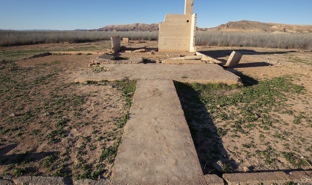
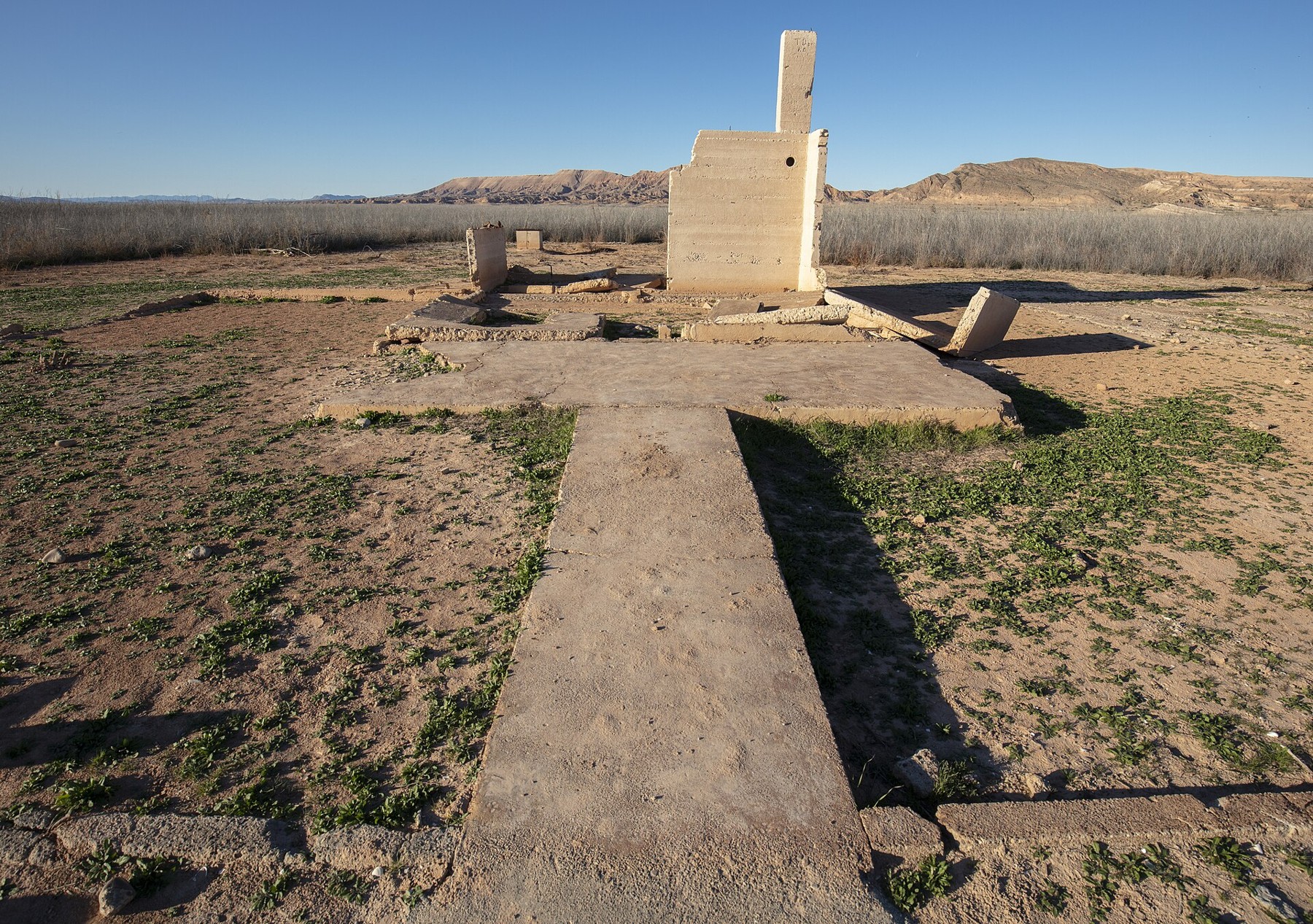
A concrete walkway leads toward the remains of a building in a broad, dry landscape. It once served an ice cream parlor in St. Thomas, Nevada. The surviving walls are an unexpectedly ordinary reminder of what a reservoir can cover: not simply acres on a project map, but places where people bought a treat, visited a neighbor, and followed familiar routes through town.
St. Thomas was inundated as Lake Mead rose behind Hoover Dam in the 1930s. Lower water levels later exposed its remains. Its history connects one of the twentieth century’s great infrastructure projects to a small community whose future was decided by the elevation of the water.
Andrew Cattoir (Lake Mead National Recreation Area). Public domain. Source and rights record. Resized for web display; no content alteration.
.jpg)
A town before the lake
Mormon settlers founded St. Thomas in 1865 in the Muddy River country of southern Nevada. The National Park Service’s account describes farming, subsequent resettlement, and a town that eventually included stores, a school, a post office, and garages serving the automobile era. It also became a stopping point along the Arrowhead Trail between Los Angeles and Salt Lake City.
This was a desert community whose location made sense through water, agricultural ground, and connections to other places. The lake did not drown a settlement accidentally built in a naturally permanent lake bed. A functioning valley became part of a new reservoir.
Nor did human history begin with the nineteenth-century town. The Park Service’s regional cultural history describes Indigenous occupation and agricultural practices long before Euro-American settlement. Archaeological sites and Native histories belong to the landscape that reservoir construction transformed. The story of St. Thomas is one layer within that longer history.
The familiar phrase “ghost town” can obscure these distinctions. St. Thomas was not abandoned because every reason for living there had vanished. Its residents had to leave because a project intended to serve a much larger region would cover their town.
A regional project changed a local horizon
Hoover Dam was built in Black Canyon on the Colorado River. The Boulder Canyon Project brought together water storage, flood control, power generation, and irrigation objectives. The Bureau of Reclamation’s project history explains the development of the undertaking and the extensive construction effort behind the dam.
Work began in 1931. The dam’s building and the reservoir’s filling were processes with different milestones, rather than one event that occurred on a single completion date. Reclamation’s history of the diversion tunnels records February 1, 1935, as the date when closure of the remaining diversion arrangement began backing water up to form Lake Mead.
Water rising behind a dam spreads upstream and into connected valleys according to their elevations. A town need not stand beside the dam to be affected. At St. Thomas, far upstream from Hoover Dam, that relationship connected everyday property to a regional operating system.
For a surveyor or map reader, the crucial question is therefore not only distance from the dam. It is height relative to the projected water surface and connection to the reservoir basin. A location that seems remote on a road map can still lie within the area that rising water will occupy.
Relocation was a process, not an instant
Residents were informed that they would have to relocate and would be reimbursed for their property. The Park Service’s history of the ruins describes people selling land, dismantling homes, and leaving neighbors. The account identifies June 11, 1938, as the day Hugh Lord, the last resident to leave, rowed away.
That specific departure is often used to symbolize the end of the town. Other households had left earlier as the water advanced, and relocation involved many separate decisions about homes, belongings, and destinations. The last departure marked the end of a longer process.
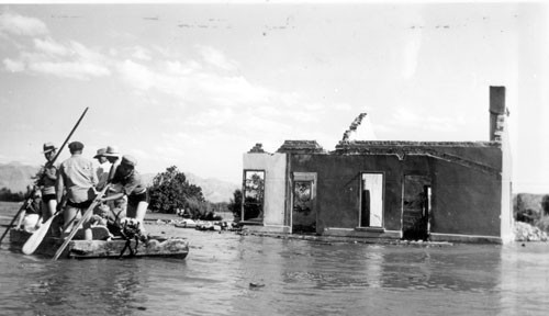
A June 1938 photograph shows a crew on a raft beside a partly submerged building. Its modest scale makes the transition tangible. Water occupies a space that had been a street or yard; the building remains recognizable even as its relationship to the ground is disappearing.
Lake Mead NRA Public Affairs. CC BY-SA 2.0. Source and rights record. Resized for web display; no content alteration.
.jpg)
Property compensation and the loss of a community address different things. A payment can assign a monetary value to land or structures. It cannot, by itself, recreate the proximity of relatives, the continuity of a shop, or a route known since childhood. Moving the contents of a house was one task; rebuilding a familiar network of relationships was another.
The elevation changed again
St. Thomas did not remain uniformly underwater forever. Fluctuating reservoir levels exposed it at different times. The Park Service’s trail description presents the remains as a historic landscape that can be explored when conditions allow.
The reappearance is dramatic, but it should not be described as a town restored to life. Roofs, interiors, trees, and many ordinary features of occupation are absent or altered. What becomes visible is an archaeological and historical remnant, changed by dismantling, inundation, exposure, and weathering.
Lake levels are also part of a changing water system. Inflows, releases, and losses affect storage. The Bureau of Reclamation’s reservoir data distinguish water-surface elevation, storage, and releases. Those are related measurements, not interchangeable quantities. A lake elevation is a dated observation within that system, rather than a permanent description of how much of the town is visible.
What the foundations can tell us
Andrew Cattoir’s 2017 photograph of the Hanig ice cream parlor, shown near the beginning of this article, connects that changing landscape with a named business. The walkway, slab, and partial wall reveal its surviving footprint. These were once the surroundings of ordinary visits and purchases, giving the remains a place in the town’s social history as well as its physical plan.
A foundation offers evidence about a building’s position and surviving form. It does not tell the complete story of its use. Historic maps, photographs, business records, and residents’ accounts can identify functions and relationships that the concrete alone cannot explain.
The same applies to a street. Its trace can locate a former route, but a map of empty lines needs other records to recover its activity. Linking spatial evidence to named places prevents a collection of ruins from becoming a generic illustration of loss. A parlor, hotel, school, and home were different kinds of places in a connected community.
Remembering both scales
Hoover Dam and Lake Mead brought major benefits and altered the development of the Southwest. St. Thomas records a local consequence within that regional history. Understanding one does not require forgetting the other. An infrastructure project can be an engineering achievement and a profound change to an inhabited landscape.
The exposed town asks readers to move between scales: from the river basin to the valley, from the projected water surface to the house floor, and from acquired property to the relationships that made a place home. The measurements explain how the town disappeared. The records and remaining structures explain what disappeared with it.
Sources and further reading
- National Park Service: St. Thomas history and the ruins and 1938 departure.
- National Park Service: Lake Mead’s regional cultural history.
- Bureau of Reclamation: Boulder Canyon Project history and diversion tunnels and the start of reservoir filling.
- Bureau of Reclamation: Lake Mead water-operation measurements.
- National Park Service: St. Thomas trail information.