

Maps & Mapping
Mapping Korea: Cadastral Records, Mountain Landscapes, and the Daedongyeojido
How Korean mapmaking combined administration, routes, regional knowledge, and distinctive cartographic traditions.
On This Page
Series: Measuring Asia
A map of a mountainous country has to do more than put towns in roughly the right places. It has to explain how one place connects to another: which valley carries the road, where a river interrupts the journey, and which ridge separates neighboring districts. Kim Jeong-ho’s Daedongyeojido makes those relationships part of the map’s visual structure.
Published in 1861, this woodblock-printed map of Korea is an achievement in selection and organization as well as geographic description. Look closely and the peninsula becomes a connected system of mountains, waterways, settlements, and routes. Reading those connections is more revealing than asking whether an old outline resembles a modern satellite map.
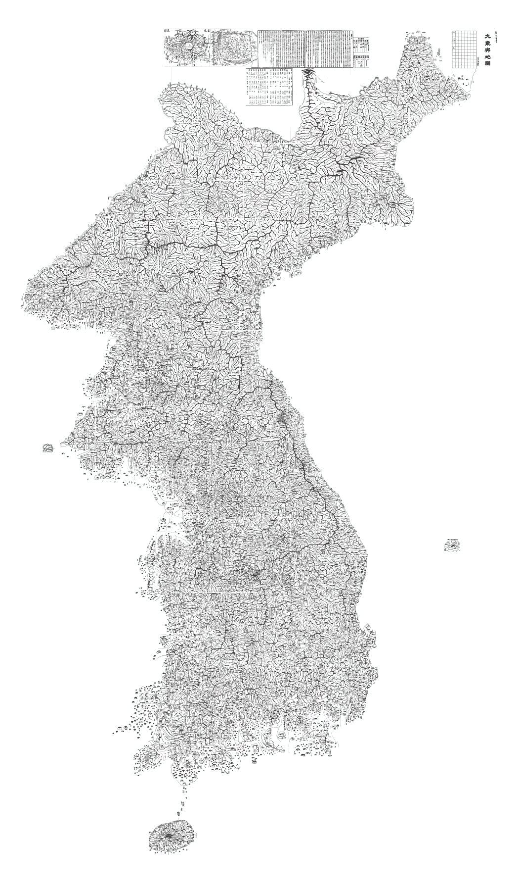
Kim Jeong-ho. Public domain. Source. Resized by WordPress.

A country organized for the reader
The National Museum of Korea’s description identifies the features that made the map useful: mountain ridges, rivers, transportation routes, and symbols for important places. Dots along the roads indicate intervals of approximately 2.5 miles (4 kilometers). A traveler could therefore read a route as a sequence of distances rather than merely a line joining two names.
Those dots deserve a moment’s attention. A road winds; the straight distance between its endpoints does not tell you how far the journey will be. Putting distance information on the route acknowledges that distinction. For a surveyor, it is a useful invitation to ask what a distance represents before reaching for a scale.
Mountains are part of the explanation
The terrain is not scenery added to decorate an otherwise complete map. The linked ridges help the eye follow the shape of the country, while the rivers and roads offer a different set of connections through it. Towns are easier to understand when they sit within those relationships.
The Jeju National Museum points to a specific example. Earlier maps often represented Jeju’s volcanic hills with simple hill symbols. Kim’s treatment gave these features more differentiated forms and included places important to the island’s administration and defense. The improvement was not just a prettier coastline; it was more useful information about the island’s interior.
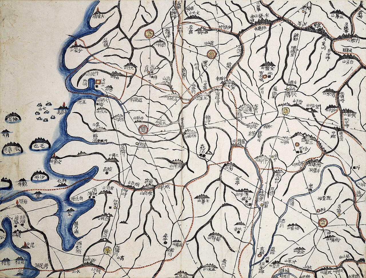
Kim Jeong-ho; Kyujanggak Institute, Seoul National University. Public domain. Source. Resized by WordPress.

What belongs on a national map?
The map brings together several kinds of geography. Rivers and mountain ranges describe terrain. Roads describe movement. County seats, military sites, and communication facilities describe how the country was organized. The museum’s account of the surviving woodblocks makes that breadth explicit.
This is where a cadastral record and a national map do different jobs. A cadastral record identifies landholdings and their boundaries. A map of the peninsula has to show relationships among regions at a much smaller scale. It cannot carry every field boundary, and the absence of those boundaries is not a defect. The useful question is whether the chosen information serves the map’s purpose.
A printed map could still change
Woodblock printing gave the map a repeatable physical form. It also left unusually direct evidence of revision. The National Museum of Korea describes corrections on the surviving blocks, and records a second edition in 1864. The engraved surface was a working tool, not simply a finished artwork to admire.
Revision is an important part of this story because a national compilation is never only an act of drawing. Information has to be selected, reconciled, symbolized, and fitted into a consistent arrangement. A correction on a block is a small surviving trace of that work. It tells us something tangible about the making of this particular map, where a sweeping claim about timeless cartographic genius would tell us very little.
Reading the object, not the legend
Kim Jeong-ho’s achievement does not require the assumption that he personally measured every road and ridge. The surviving map shows what he brought together; establishing the source of each line is a separate historical question. The safest reading starts with the object, its date, its symbols, and the evidence of printing and correction.
A digitized overview helps us recognize the country. A detailed sheet asks us to slow down and read it. Follow a road, count its distance marks, look for a crossing, and notice what the mountain symbols tell you about the route. That is where Daedongyeojido becomes more than a famous old map: it becomes a carefully organized way to understand a landscape.
Sources and further reading
National Museum of Korea: printing woodblocks and map conventions; National Museum of Korea: surviving corrections; Jeju National Museum: Jeju in Daedongyeojido.