
Boundaries & Land Rights
Four Million Acres: The Scale and Legacy of the Disston Purchase
Four million acres for $1 million: the scale of the Disston purchase and how its land, companies and investments helped shape Florida’s growth.
On This Page
At 160 acres apiece, it would take 25,000 quarter-section farms to make up four million acres. That is 6,250 square miles altogether, enough acreage to make a surveyor pause over the arithmetic before looking for the deeds. In 1881, Hamilton Disston and his associates agreed to buy that much Florida land for $1 million: twenty-five cents an acre.
The acreage was spread across separate tracts, and the purchase’s importance extended well beyond its size. Florida’s land fund was entangled in railroad debt. Disston’s investment helped release land for sale and development, linking an extraordinary transaction to the growth of towns, transportation and settlement across the state.
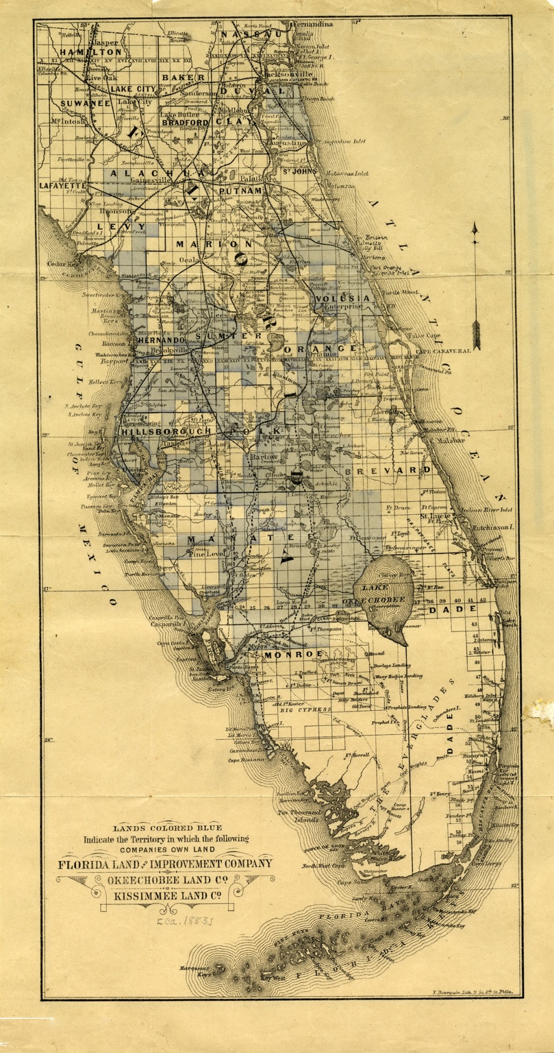
Public-domain map: State Library of Florida, Florida Map Collection, fmc0182, via Florida Memory. Open the local map copy.
View this map in the LostSurveyor Map Archive
How large was four million acres?
A half-million-acre purchase would be an enormous undertaking on its own. That was approximately the size of Richard J. Bolles’s Everglades purchase in 1908, a deal tied to drainage and the sale of smaller tracts. Disston’s agreement covered eight times as much land.
For a more recent Florida comparison, consider Babcock Ranch. Its whole-property purchase in 2006 covered about 91,362 acres, including the 73,575 acres sold to Florida and Lee County for preservation. It would take about 44 purchases of that size to match Disston’s four million acres.
The peninsula map puts those numbers into perspective. Tampa Bay and Lake Okeechobee provide familiar bearings, while the pale blue areas carry the eye across a much wider landscape. It identifies territory containing lands of the Florida Land and Improvement Company, Okeechobee Land Company and Kissimmee Land Company across a substantial part of Florida. The shading shows the reach of those associated interests, not ownership of every acre within it.
Why Florida was ready to sell
Disston was a Philadelphia saw manufacturer investing in a state with abundant land and scarce cash. The seller, Florida’s Board of Trustees of the Internal Improvement Fund, managed land intended to support improvements such as railroads. Railroad defaults had left the fund with debts it could not meet through ordinary land sales. Interest and litigation costs kept growing, and its lands were under federal court control.
Governor William D. Bloxham helped bring the agreement together. Historian Joe Knetsch’s account records the trustees’ approval in May 1881. According to the trustees’ 1888 report to the U.S. Senate, the sale paid nearly all the fund’s debts and released the remaining lands.
That release mattered far beyond the acreage sold to Disston. Land could once again help finance railroad construction and attract investment. Transportation, land sales and settlement reinforced one another: a railway made property easier to reach, while sales and development gave the railway customers and freight.
From one agreement to many holdings
The purchase brought together investors and companies as well as land. In his 1888 Senate statement, Disston described the agreement made by himself and his associates and the formation of the Florida Land and Improvement Company. Sir Edward James Reed and fellow investors took over half the original contract, a two-million-acre share within the four-million-acre total.
The land was selected in separate bodies using the existing system of sections, townships and ranges. Those sections could be sold, subdivided or placed in the hands of associated companies. Bourquin’s circa-1883 map captures that expanding business geography a couple of years after the purchase.
Alongside the purchase was a separate drainage venture. Disston and his associates agreed to reclaim land in exchange for half the acreage drained, work carried on by the Atlantic and Gulf Coast Canal and Okeechobee Land Company. The purchase exchanged money for land; the drainage agreement exchanged reclamation work for land.
Where the acreage became places
The November 1882 Map of Hillsborough County, Florida brings the story closer to home around Tampa Bay. Section lines, named owners and settlements replace the broad view of the peninsula with recognizable pieces of land. The Pinellas peninsula is still part of Hillsborough on this sheet; Pinellas became a separate county in 1912.
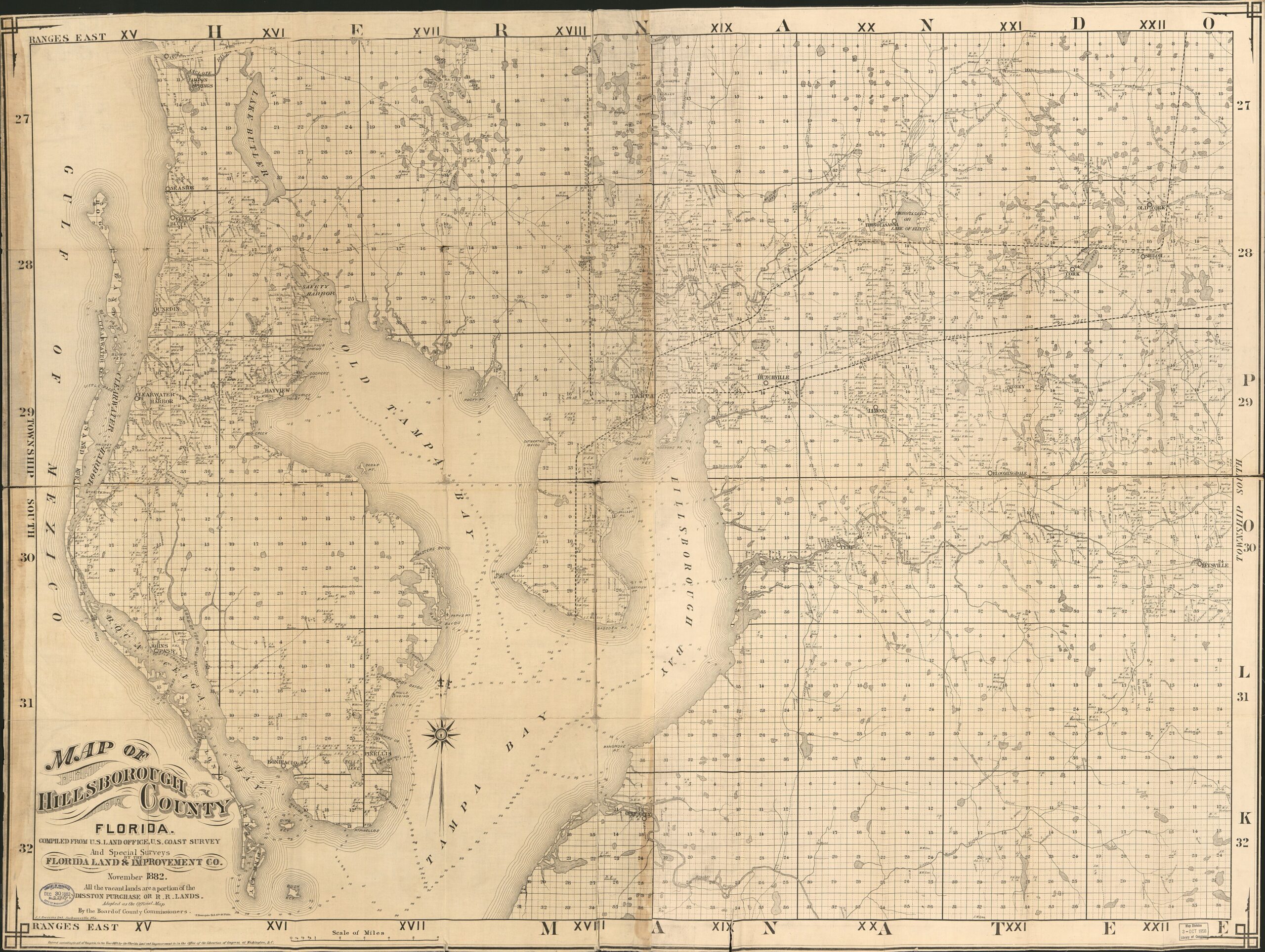
Public-domain map: Florida Land and Improvement Co.; J. J. Treveres; F. Bourquin. Library of Congress, Geography and Map Division, digital ID g3933h.la000076. Institutional record · Wikimedia Commons source reproduction · Open the larger local viewing copy.

View this map in the LostSurveyor Map Archive
In Tarpon Springs, the connection between investment and town building is particularly clear. The local historical society records that Mathew Robinson Marks laid out the town in 1882. Disston and his associates formed the Lake Butler Villa Company to sell land, and Disston later donated a railway right-of-way. Surveying, a sales organization and transportation helped an existing settlement grow.
San Antonio offers another local example. Attorney Edmund F. Dunne, who worked on the Disston arrangements, selected the town site in 1882 and promoted a Catholic colony. The St. Leo Abbey historical documentation and West Pasco Historical Society’s account trace the connection to land reserved for a monastery and the Benedictine community at Saint Leo. A large land venture helped shape the institutions of a community as well as its streets and lots.
These are the smaller decisions behind the enormous total: lay out a town, sell a tract, reserve a site for a church, secure a route for a railway. Four million acres supplied room for many such ventures. Turning that room into a place people could live and work still depended on money, access and sustained effort.
Growth brought conflicts and consequences
The bargain had critics from the beginning. Settlers worried about their claims, and opponents challenged the disposal of so much public land to large investors. The 1888 Senate investigation gathered those complaints alongside the trustees’ and Disston’s defenses. Florida’s development created opportunities while also intensifying disputes over who would benefit from its land.
The region already had a human history extending far beyond its land companies. Seminole communities had established themselves in the Everglades while resisting removal. Commercial maps organized the landscape for sales, leaving much of that history outside their borders and legends.
Drainage changed the physical landscape, too. The National Park Service’s development history describes the limited reach of the early canals, followed by much greater changes from later dredging, roads and water-control projects. Disston’s ventures were part of the push to turn wetlands into agricultural property, an ambition that would reshape South Florida over generations.
A purchase that helped shape Florida
Four million acres is impressive arithmetic. The lasting significance lies in what followed: a land fund able to act again, new networks for selling property, and investments in towns and transportation. Bourquin’s map shows the breadth of those interests; the Hillsborough sheet shows individual landowners’ holdings. Between those two views is the story of how a vast land purchase helped shape Florida’s growth, one sale, town site and railway connection at a time.
Sources and map provenance
- U.S. Senate, Public Lands in Florida, Report No. 2288, September 26, 1888: contemporary investigation; trustees’ statement, especially pp. 51–53; Disston’s response, pp. 59–64.
- Joe Knetsch, “Hamilton Disston and the Development of Florida,” Sunland Tribune, vol. 24, article 3: negotiations, trustees’ minutes, Reed arrangements and contemporary criticism. Full-text copy.
- Florida Memory, fmc0182: State Library catalog identification, circa-1883 dating and source of the full-sheet reproduction.
- Library of Congress, Map of Hillsborough County, Florida (November 1882); public-domain reproduction and provenance on Wikimedia Commons.
- Holmberg v. Hardee, 90 Fla. 787 (1925): Bolles contract, deed, estimated acreage and price; U.S. Army Corps of Engineers, Babcock Ranch project history: 2006 whole-ranch transaction and subsequent conservation acreage.
- Tarpon Springs Area Historical Society, Historical Overview; St. Leo Abbey Historic District National Register nomination, section 8; West Pasco Historical Society, San Antonio; county-history records from Pinellas County.
- National Park Service: Native Peoples and Development in the Everglades.
Discussion
Questions, field experience, and thoughtful observations are welcome.