
Boundaries & Land Rights
Andrew Ellicott: Drawing America’s Southern Line
From Washington’s future streets to the border of Spanish Florida, Andrew Ellicott turned national ambitions into lines on the ground—and left a remarkable trail of maps and monuments.
On This Page
Near Alabama’s Mobile River, a weathered sandstone marker carries two versions of the same boundary. One face identifies the United States; the other names the dominion of Spain’s King Charles IV. Both bear the year 1799 and the latitude that separated the two powers. The stone is small, but the story behind it reaches from the streets of Washington to the forests and waterways of the Gulf South.
Andrew Ellicott helped turn that international agreement into something people could actually find. A treaty could declare where a country ended. Getting the line onto the landscape required people, instruments, travel, and cooperation between governments that had plenty of reasons to distrust one another.
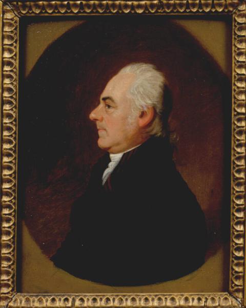
Jacob Eichholtz / New York Historical, via Wikimedia Commons. Public domain. Source.
_1916_3.jpeg)
A Career Along the Edges
Ellicott’s working life followed the unsettled edges of a young United States. After teaching mathematics in Baltimore, he took on surveys of boundaries and places that needed better maps. His commissions included extending the Mason–Dixon line and studying the Niagara River and falls. These were assignments in which a measurement could become a public fact: a border, a place on a map, a reference that another traveler would later depend on.
By the early 1790s, he had another extraordinary commission. The national capital was taking shape beside the Potomac, and Ellicott was responsible for surveying the new federal district’s boundary. He established his initial camp at Jones Point, near Alexandria. Benjamin Banneker joined the early work, bringing his knowledge of astronomy and calculation to the survey.
There were two related undertakings: locating the district’s outer boundary and laying out the city within it. Pierre L’Enfant devised the city’s ambitious plan. Ellicott helped bring that design into a form that could be engraved, printed, and used. Their work became part of the capital’s enduring geography, long before most of its familiar buildings existed.
A Capital on Paper
A look at Ellicott’s 1792 plan of Washington reveals an optimistic city. Broad avenues cross a street grid, waterways frame the site, and space is reserved for the institutions of a national government. The sheet presents a future people were still trying to build.
That future came with friction. L’Enfant’s relationship with the commissioners deteriorated, and President George Washington dismissed him in 1792. Ellicott then completed and revised the plan for publication. The Library of Congress’s account of these events shows how closely the map’s making was tied to arguments about authority, deadlines, and the sale of city lots.
The resulting engraving deserves a second look beyond its famous avenues. It is a reminder that a city’s public image can emerge from negotiation as well as imagination. Surveyors, planners, printers, property owners, and officials all had a hand in what eventually reached the public.
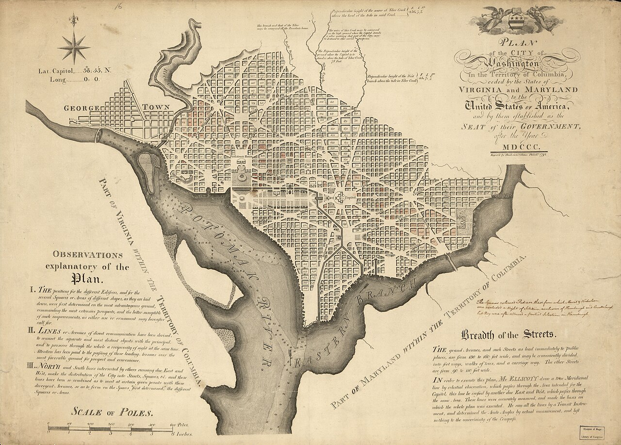
Andrew Ellicott; Thackara & Vallance / Library of Congress, Geography and Map Division, via Wikimedia Commons. Public domain. Source.
South to Spanish Florida
Ellicott’s next major boundary story unfolded far from the capital. The 1795 Treaty of San Lorenzo, also known as Pinckney’s Treaty, established the 31st parallel as the boundary between American territory and Spanish West Florida. Ellicott became the American commissioner charged with helping locate that line.
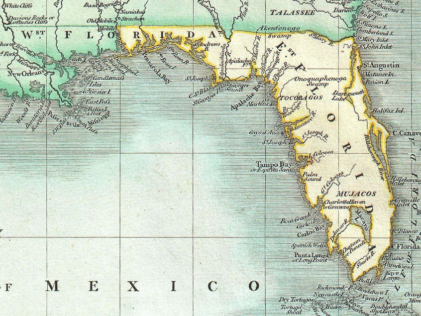
John Cary; Geographicus Rare Antique Maps; existing map excerpt. Public domain. Source. Resized by WordPress.

The name “West Florida” can mislead a modern reader. The Spanish territory extended along the Gulf Coast into areas now within other states. This was a border between countries, cutting across a southern landscape whose political labels were still changing. It also crossed a region with Indigenous communities and histories that predated either government’s claim.
The commission occupied years rather than a single season. Ellicott’s published journal covers his work from 1796 into 1800. Its scope gives a sense of the assignment’s scale: the Ohio and Mississippi rivers, the Gulf of Mexico, West Florida, part of East Florida, and the boundary itself all appear in its maps and descriptions.
The book records more than positions. Ellicott wrote about rivers, soils, natural features, and diseases along the route. The journey reads through those subjects as well as through its official mission. Moving a surveying party through the South meant encountering a whole region, with the line only one part of the experience.
The Stone That Still Speaks
The marker near the Mobile River was set by a joint American–Spanish party on April 10, 1799. Its inscriptions made the agreement visible in two languages. For the crews who established it, the monument tied diplomatic instructions to a particular piece of ground.
The international boundary did not last indefinitely. Spain’s control in the region receded, and the United States obtained Mobile in 1813. The stone outlived the political arrangement it marked. That is part of its appeal today: an ordinary-looking object preserves a moment when the geography of the southern United States was still being negotiated.
Ellicott’s journal offers another surviving marker, this one on paper. Its maps allow readers to follow the project’s geographical reach, while its descriptions preserve the concerns of a traveler working through an unfamiliar assignment. Together, monument and journal bring a distant border into focus.
A Teacher Behind Another Famous Journey
In 1803, Meriwether Lewis came to Lancaster, Pennsylvania, to study with Ellicott before heading west. Lessons in celestial observation and surveying helped prepare Lewis to record the expedition’s journey. Ellicott’s influence thus traveled onward in the work of a student whose name became far more familiar.
He later taught mathematics at West Point. The progression is striking: boundary commissions, a new capital, an international survey, and instruction for the next generation. Across these roles, Ellicott helped people turn geographical intentions into records that could be shared.
His legacy is easy to encounter without recognizing him. It appears in an engraved city plan, in accounts of an expedition, and in a sandstone marker beside a southern river. Each offers a different way into the same life—a surveyor who repeatedly found himself where a nation was trying to decide what its map should mean.