
Boundaries & Land Rights
Record the Sketch: Why a Legal Description Needs Its Drawing
When a sketch has already been prepared with a legal description, recording only the words leaves useful work behind. Keeping both together helps title companies, legal professionals, landowners, and surveyors understand the parcel without rebuilding the picture.

On This Page
In my work, I prepare sketches and legal descriptions for land sales, easements, and other interests in land. Just about every time I prepare a new legal description, and always when it is a metes-and-bounds description, I prepare an accompanying sketch. In some cases, the instrument is recorded with only the description. Sometimes I am asked to send the description as a Word file, knowing the sketch may not follow it into the record.
The sketch is valuable because it lets me, or anyone else, see at a glance what the description covers. I often work on complicated developments where dozens or hundreds of parcels and easements are created: rights-of-way, development parcels, utility easements, access easements, and drainage easements, to name a few. Having the sketches available helps me and anyone coming behind me sort through those parcels quickly. Even when I return to my own recorded description, I cannot look at six pages of bearings and distances and immediately say, “Oh yes, that is this parcel.”
When the sketch is missing, I may have to re-enter the bearings and distances just to determine where the parcel lies among complicated, subdivided boundaries. Imagine doing that for a title commitment with 50 exceptions, some containing several legal descriptions.
If a sketch has been prepared to accompany a description, I want title companies, legal professionals, and landowners to keep the two together when recording the instrument. The sketch helps show how the written calls fit together and where the described land lies. Although it is not a boundary survey, it can also contain useful information about nearby boundaries and other parcels that adds context beyond the description itself.
The Sketch Is Already Part of the Work
Most surveyors I know prepare sketches to go with their legal descriptions because plotting the written calls is such a useful quality check. A missing call, a bearing running in the wrong direction, a boundary that fails to close, or an exception in the wrong place can become much easier to spot on a drawing. The sketch and description can then be compared and corrected together before the work is delivered.
That work has already been done when the completed package reaches the people preparing the instrument for recording. Leaving the sketch behind discards a useful part of the finished work. The next person may have to enter and plot the same calls again, not to produce something new, but simply to understand what was already prepared. Keeping the sketch in the record saves that effort and makes the description easier to use.
What the Written Description Does
A legal description identifies the land to which an instrument applies. In a metes-and-bounds description, the writer may lead the reader from an identifiable reference point to a point of beginning, then around the boundary through successive directions and distances. References to monuments, adjoining boundaries, curves, and earlier records can carry information that a simple outline cannot convey.
Other descriptions work through an established reference system. A lot-and-block description points to a particular lot on an identified plat; a description within the Public Land Survey System uses townships, ranges, sections, and their subdivisions. The Bureau of Land Management’s Specifications for Descriptions of Land explains these approaches and the importance of clearly identifying the intended land.
A complicated property interest may require a lengthy description, running to dozens of pages in extreme cases. An easement can follow a winding corridor, a conveyance can exclude several smaller tracts, and a remainder can depend on earlier transactions. Those details need to be preserved. To see the resulting shape and relate it to another parcel, a reviewer may have to enter and plot a substantial number of calls.
Three Pages Without the Picture
The recorded description below spans three pages and describes land in parts of five sections of the Public Land Survey System. A standard section is roughly one mile square. The description includes many long courses and curves. The final page contains only the conclusion, but the full description still presents a substantial amount of information to enter, plot, and relate to the surrounding boundaries.
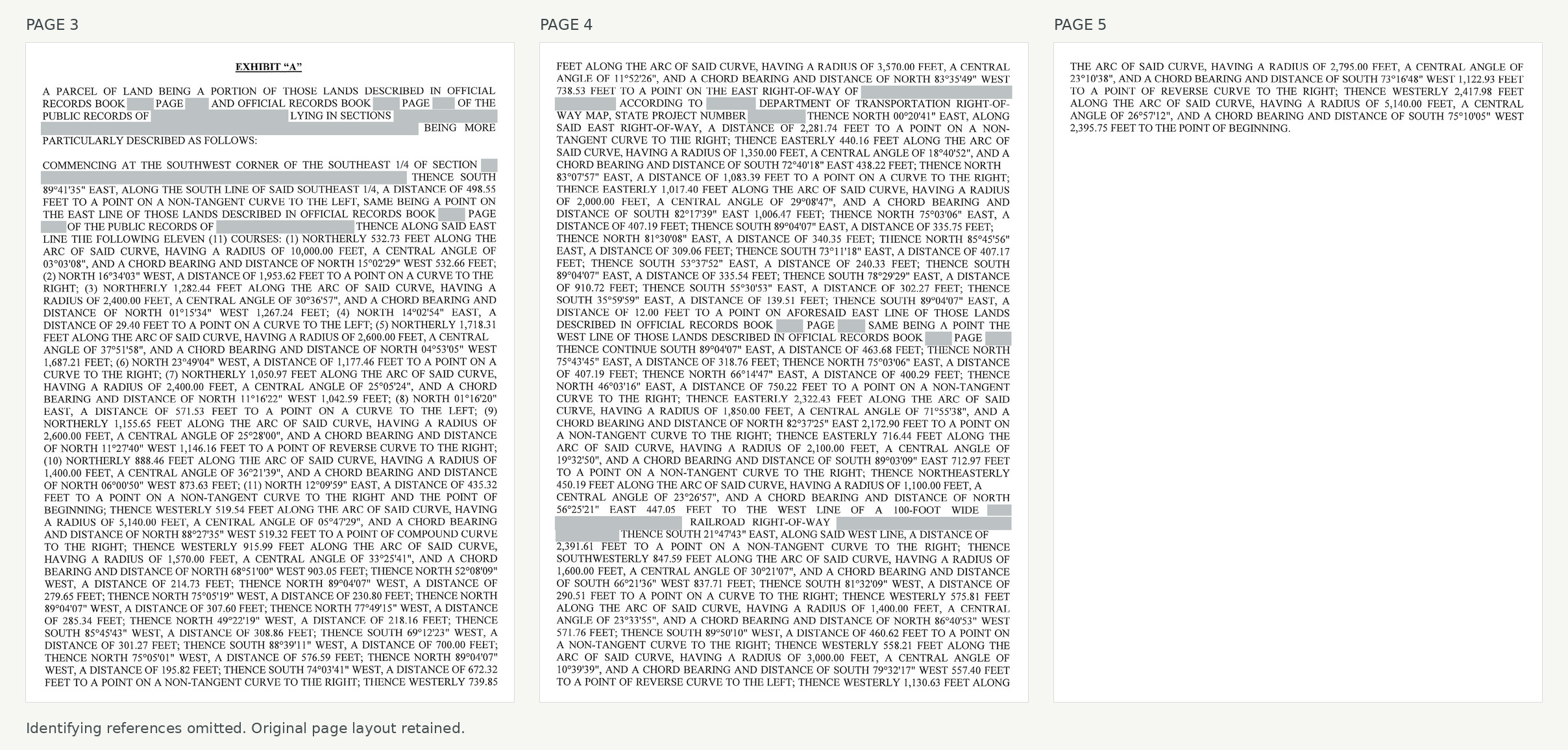
I know a sketch was prepared for this description because I have seen it. Looking at these recorded pages, however, the reader has only the text to work with. You can see that there is a great deal of information, but you cannot tell at a glance what shape it describes or how it fits together. That is precisely where the accompanying sketch would help.
What the Sketch Adds
The fictional description below is deliberately simple. All the calls run north, south, east, or west, so a surveyor can form a rough picture more readily than with a long, winding description. Read the words first, then compare them with the sketch. Even in this small example, the drawing makes the shape, dimensions, and exception easier to understand.
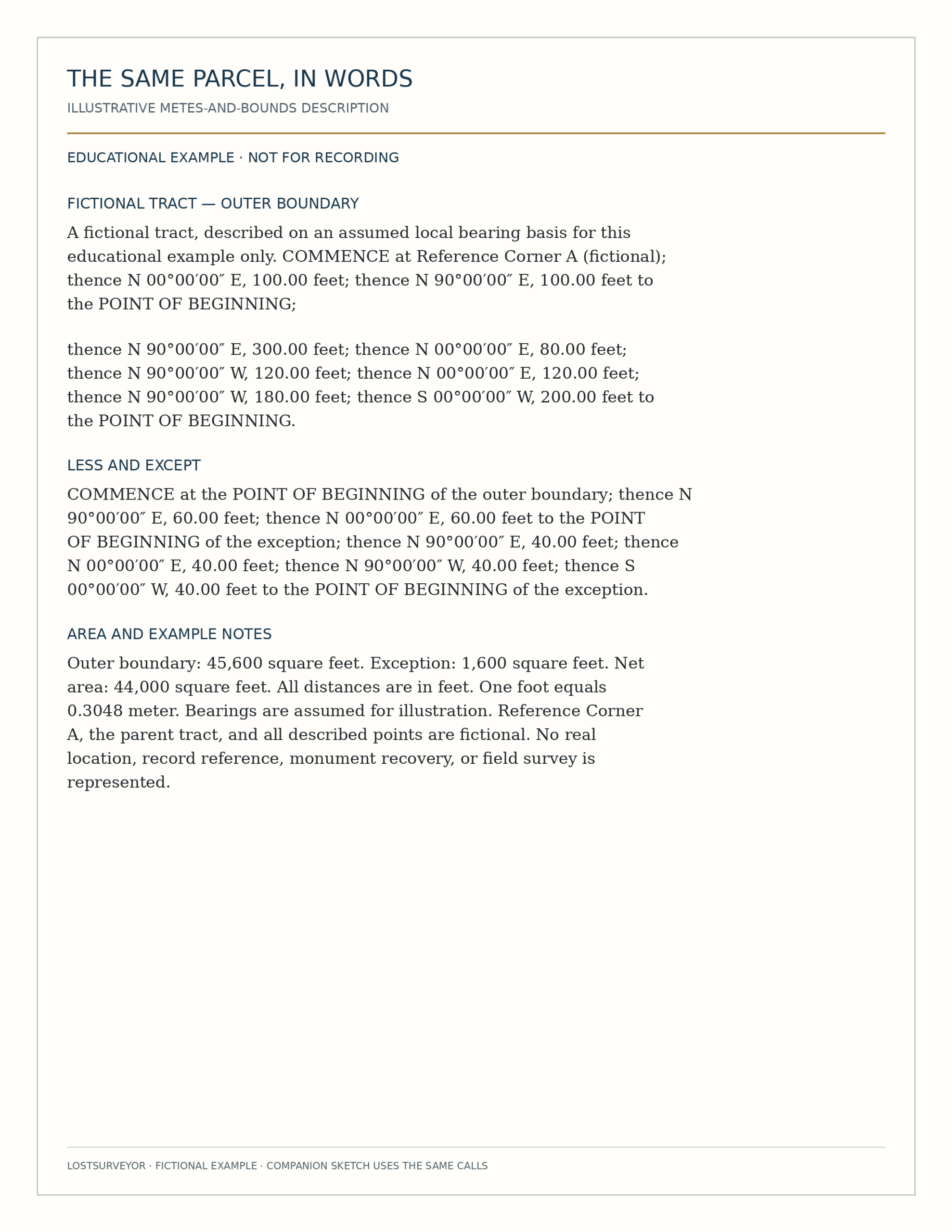
Original LostSurveyor educational illustration. Fictional parcel; not a survey or a recording-ready instrument.
The outer boundary contains an inward step, and a small square is excluded from the tract. The square exception measures 40 feet by 40 feet and removes 1,600 square feet. The net tract contains 44,000 square feet, approximately 1.01 acres. Both illustrations use the same checked dimensions.
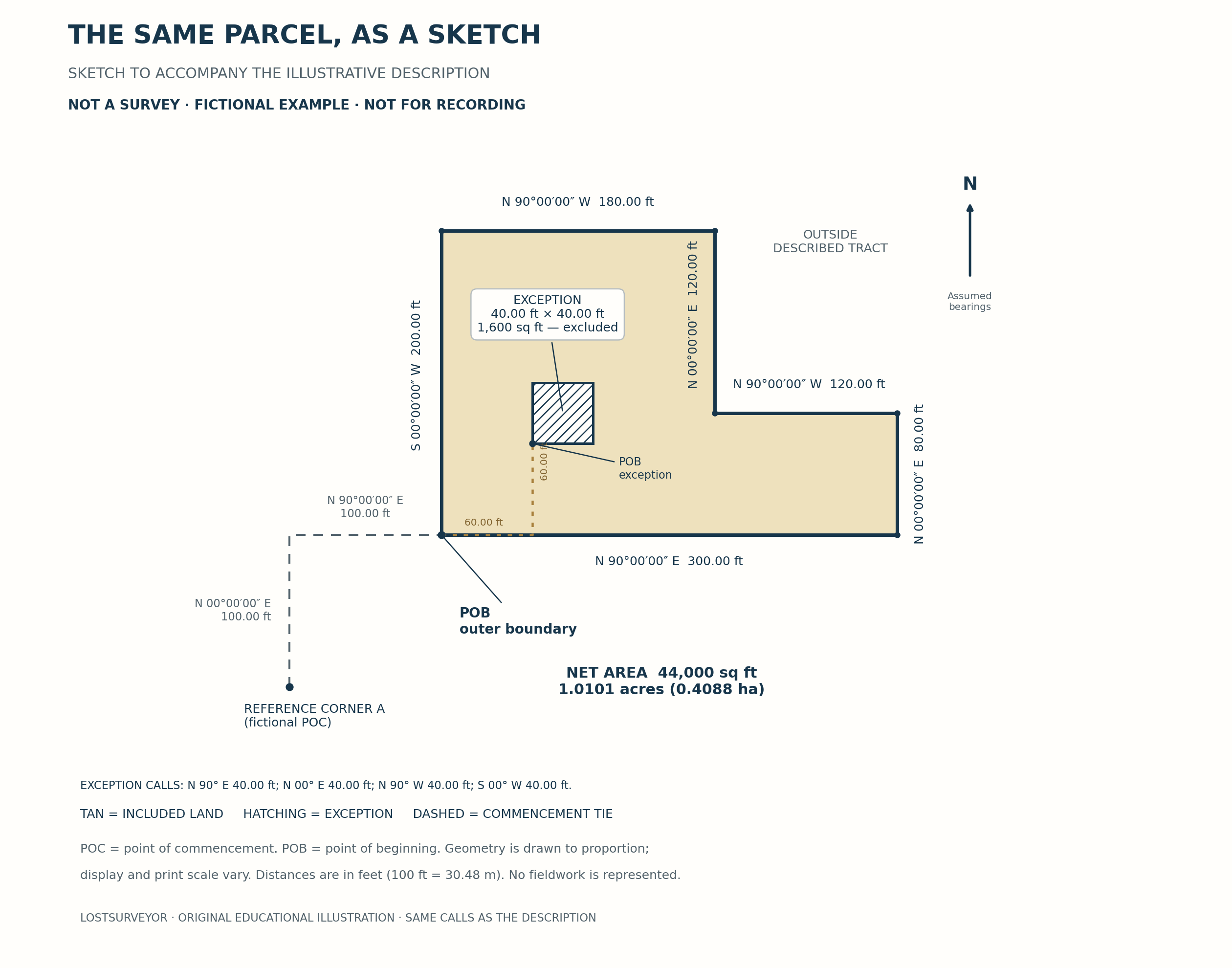
Original LostSurveyor educational illustration. Fictional parcel; not a survey or a recording-ready instrument.
A useful sketch also distinguishes the point of commencement from the point of beginning and separates boundary lines from reference ties. Where relevant, adjoining boundaries and recorded interests show how the described parcel fits into the surrounding land. That context becomes especially helpful where successive subdivisions have made the relationships difficult to follow.
Florida’s Rule 5J-17.052(6)(b) calls for an accompanying sketch to identify itself as not being a survey. Even so, an accompanying sketch can provide additional context that helps the reader quickly understand where the parcel lies.
Keep the Prepared Package Together
My concern is with a completed sketch-and-description package that gets separated before recording. Without the sketch, a group of connected easements becomes a collection of bearings, distances, and references that takes effort to reconstruct. With the sketches, the reader can locate the relevant piece much more quickly and then concentrate on checking the details.
That convenience helps everyone involved. A title company can use the sketch to get oriented while reviewing the interests affecting a property. A legal professional can relate an exhibit to the transaction being prepared. A landowner can better understand which portion of the property is involved and ask more informed questions. The sketch gives each reader a useful starting point while the written description preserves the detailed calls and references.
The description and sketch still need to agree. If either has been revised, they should be checked together so that the recorded set contains the matching version. Dates, revision information, parcel identifiers, and sheet numbers help keep the package intact. Where the instrument refers to a graphic exhibit or the pages are numbered as a set, it is worth checking that every intended sheet is included and legible in the recorded copy.
A sketch does not eliminate the need for professional review. It does make that review easier to begin. Instead of spending time rebuilding a picture solely to find out which parcel is involved, the reader can start with the picture that was prepared with the description and use it while examining the records.
Record the Work That Is Already Done
When a complete sketch-and-description package is available, recording only the text wastes an opportunity to make the record more useful. The sketch has already served the preparer as a quality check. Keeping it with the description allows that same work to help the title examiner, legal professional, landowner, and next surveyor.
If you are preparing an instrument for recording and have the accompanying sketch, include it with the description. I should be able to return to my own recorded work and find the drawing that helps explain it. Everyone coming after me should have that same convenience. We have already done the work to put the parcel on paper. Let’s keep that work available.
Sources and Further Reading
- Florida Administrative Code, Rule 5J-17.052, subsection (6), Descriptions/Sketch to Accompany Description, including identification of an accompanying sketch as not being a survey.
- Bureau of Land Management, Specifications for Descriptions of Land, revised 2017. Background on description types and identifying land.
The paired parcel illustrations are fictional teaching examples, not recording-ready instruments. The recorded-description excerpt is presented separately to show the density of a real written description.