
Maps & Mapping
A Million Points of View: What LiDAR and Laser Scanning Really See
A point cloud can make a building transparent on screen and a forested hillside surprisingly legible. The fascination begins with laser ranging—and continues with the decisions made after the scan.
On This Page
A point cloud can make a familiar place look wonderfully strange. Walls become constellations. Trees turn into flecks of color. A roof disappears with a click, leaving the rooms below exposed on the screen. The scene feels part photograph, part architectural ghost.
That first impression is worth enjoying. It is also worth looking past. LiDAR and laser scanning are measurement technologies before they are visual effects, and the most interesting question is often what those glittering points allow someone to discover.
The distance is in the returning light
LiDAR stands for Light Detection and Ranging. In a pulsed system, a laser emits light and the instrument measures the returning signal to determine range. Combining ranges with the direction of measurement builds a collection of positions in three dimensions: a point cloud.
On an aircraft, the calculation also needs the platform’s position and orientation. Satellite positioning, inertial measurements, scan angles, and calibration help place the laser observations in the world. A ground-based scanner begins from a different physical arrangement, often a tripod, but faces the same larger task of turning measurements into a useful spatial record.
The cloud is not automatically a finished map. It is a rich collection of observations from which surfaces, sections, dimensions, contours, and other products can be developed. Choosing the product means choosing which part of the scene matters.
The forest and the hill are different stories
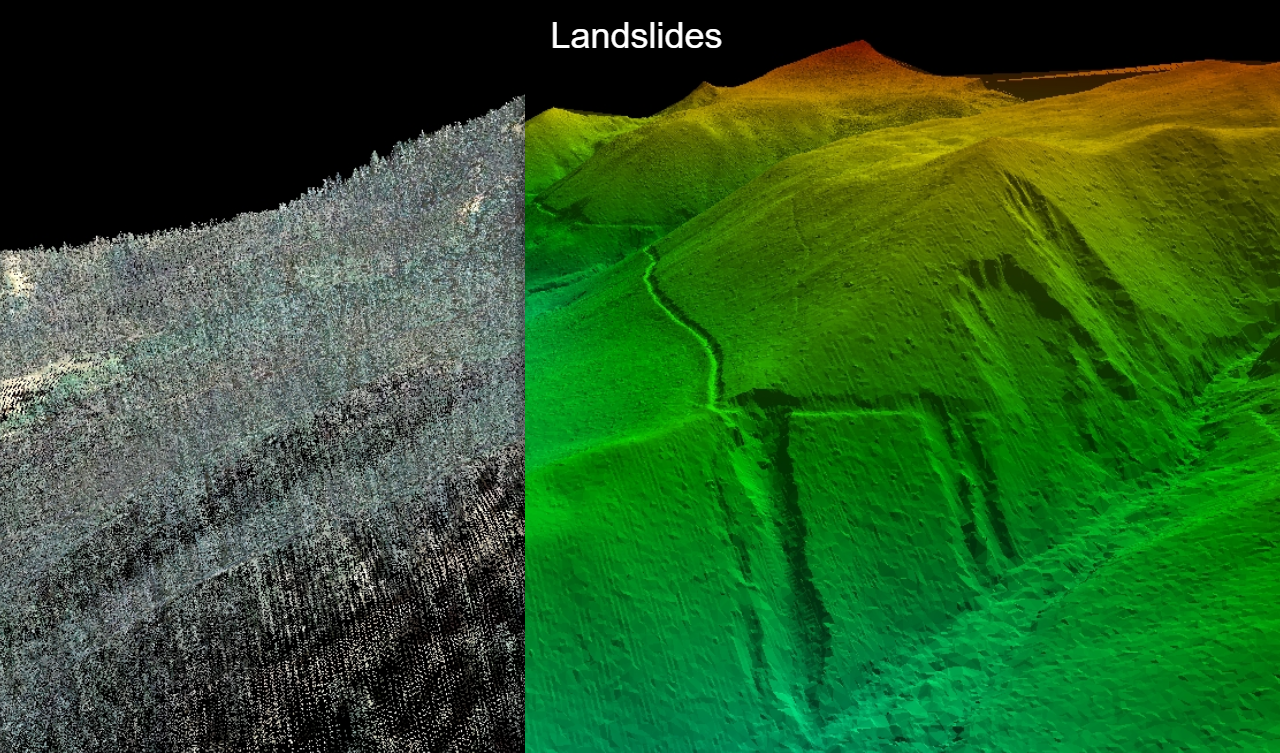
Image: U.S. Geological Survey, public domain. Source and description.
Airborne LiDAR can record reflections from vegetation and from the ground where light reaches it. Processing can identify likely ground observations and use them to construct a bare-earth digital elevation model. Trees and buildings are excluded from that particular product, rather than treated as the terrain itself.
The phrase “seeing through trees” is convenient shorthand, but it can create the wrong mental picture. The laser is not a magical beam passing straight through every leaf and trunk. Ground observations depend on opportunities for light to reach the ground and return. Dense cover can leave fewer useful observations beneath it.
The USGS comparison above shows why this matters. Landforms hidden by the forest become legible in the terrain model. The canopy was visually dominant; the shape of the hillside was the feature of interest. Changing the representation changes what the viewer can notice.
I find this one of LiDAR’s most satisfying qualities. A place does not have to be remote or exotic to contain something difficult to see. Sometimes the discovery is an old slope movement sitting quietly beneath a very ordinary-looking stand of trees.
A room has its own blind spots
A terrestrial scan of a building or industrial site confronts a more immediate obstacle: objects block other objects. A column hides part of a wall. Equipment conceals the floor behind it. A scanner in one position cannot observe every surface simply by taking more measurements.
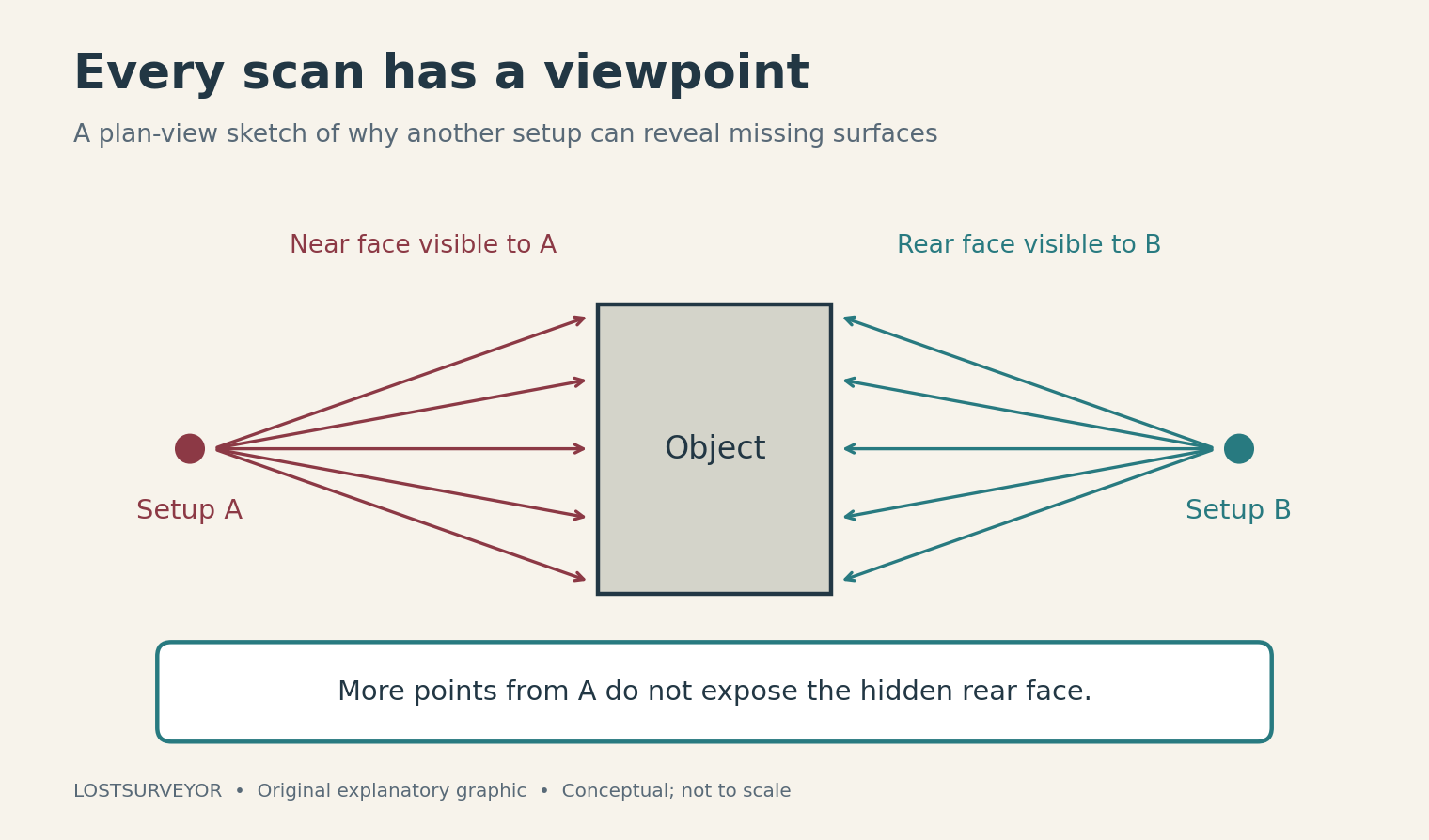
Original explanatory graphic for LostSurveyor. Conceptual plan view; not to scale.
Multiple setups give the instrument different viewpoints. Their data then need to be registered—aligned into a common relationship. That may use identifiable targets, matching features in overlapping clouds, or other supporting information. Tying the result to survey control is a further connection to the project’s reference system.
Registration is less glamorous than the first fly-through, but it is what lets separate observations tell one coherent story. A collection of beautifully detailed scans that disagree about where a wall belongs is not yet a dependable model.
The useful work comes after the spectacle
A point cloud can support a section through a building, a stockpile volume, a contour surface, or comparison with a design. It can also preserve visible conditions for later examination. The office gains a way to revisit a scene, even when the next question was not the one that first attracted attention in the field.
That flexibility does not mean every later question has an answer. The needed surface must have been observed, and the measurements must suit the purpose. A model can be visually impressive while containing gaps, noisy returns, or uncertain interpretation. Dense data and dependable data are related goals, not interchangeable descriptions.
The worthwhile ending to a scanning job is therefore something more useful than a large file: a product that communicates the right features, with its spatial relationships understood. The point cloud may be the material; the surveyor helps decide what to build from it.
LiDAR’s great gift is a change in how we can look at a place. It gives us many observations to explore, and sometimes a view that ordinary photographs cannot supply. The delight is real. So is the craft required to turn that delight into a clear account of the ground, the building, or the space in between.
Sources and further reading
- NOAA: What is LiDAR? — Laser ranging, airborne positioning, and common mapping products.
- USGS: LiDAR and digital elevation models — Why a point cloud and a bare-earth surface are different products.
- USGS: Point cloud versus bare-earth terrain — The public-domain landslide comparison reproduced above.
- Leica Geosystems: A laser scanning workflow — A manufacturer example of capture, overlap, registration, and quality review.
- Leica Geosystems: Working with point clouds — Registration, control integration, classification, and derived deliverables.