

Engineering & Infrastructure
Surveying the Iron Road, Part 2: The Transcontinental Railroad and the Geography of a Nation
The surveys, competing routes, mountain passes, land grants, and field crews behind the first transcontinental railroad.
On This Page
- 01 — Introduction
- 02 — Several Ways Across a Continent
- 03 — The Sierra Nevada Made Height Expensive
- 04 — Two Companies, Many Working Lines
- 05 — Promontory Was a Junction, Not the Whole Journey
- 06 — The Work Behind the Ceremony
- 07 — Land Beyond the Tracks
- 08 — Reading Beyond the Last Spike
- 09 — Sources and Further Reading
Series: Surveying the Iron Road
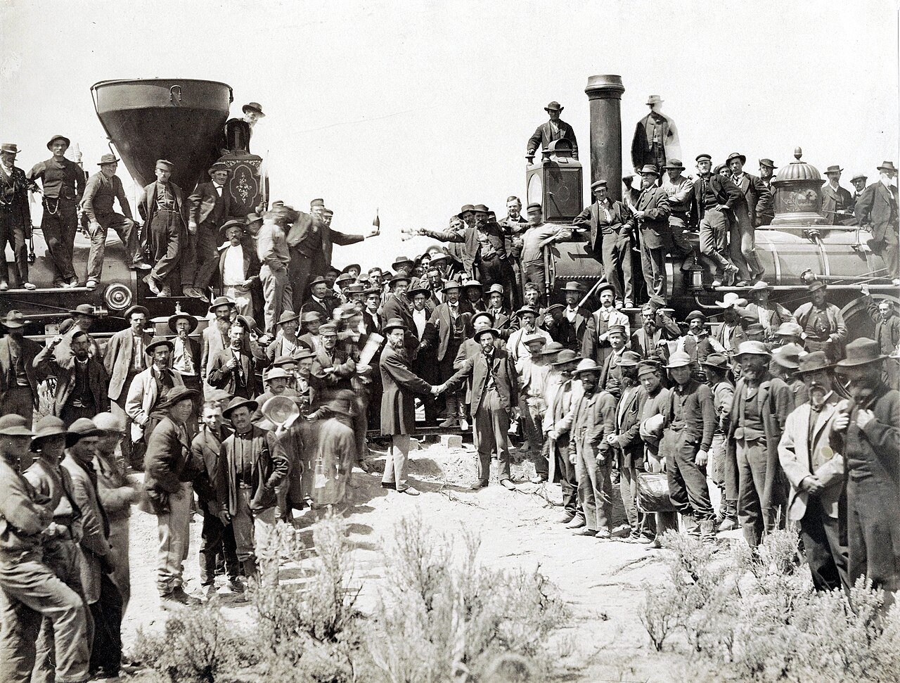
The photograph at Promontory shows a connection being celebrated. It cannot show all the routes that were considered and rejected before the rails arrived. The first transcontinental railroad grew from reconnaissance, company surveys, construction decisions, and federal policy. Its surveyed line was both an engineering choice and a powerful claim about the country’s future.
Several Ways Across a Continent
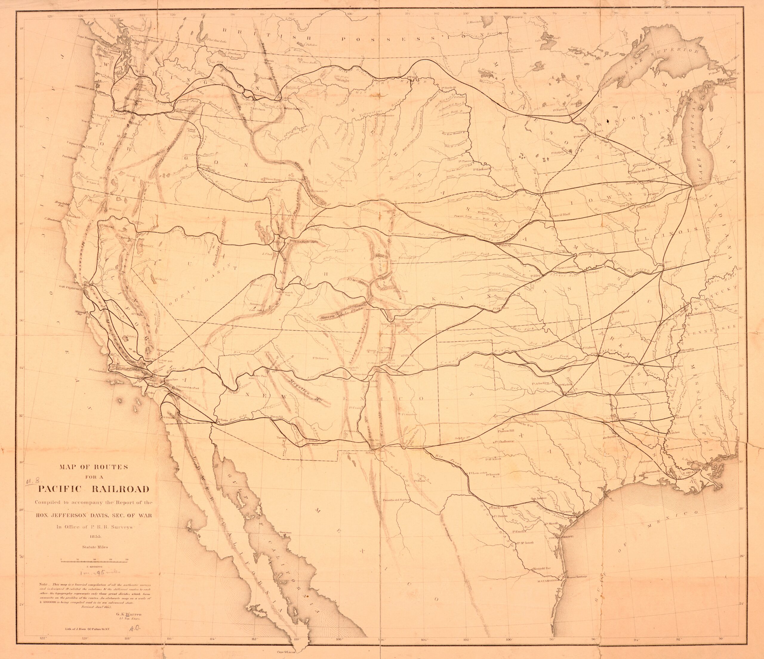
Office of Pacific Railroad Surveys; New York Public Library. Public domain. Source. Resized by WordPress.

Congress funded explorations for possible Pacific railroad routes in 1853. The resulting maps and reports described broad corridors, terrain, and resources. They expanded geographic knowledge, but they were not construction plans ready to hand to a grading crew. The Library of Congress account distinguishes this federal program from the later choice and building of the railroad.
A reconnaissance can show that a corridor is promising without proving every mile is practical. A railroad location requires grades, curve geometry, crossings, and quantities at a much closer scale. The distinction is easy to lose when several surveys appear as similarly confident lines on a regional map.
The Sierra Nevada Made Height Expensive
On the western approach, Theodore Judah’s surveys helped demonstrate a route through the Sierra Nevada. His 1862 report addressed the preliminary survey, estimated construction cost, and revenue. Even its title is a reminder that measuring a route was tied to making a case for building it. The Library of Congress research guide identifies the report among the project’s surviving records.
Mountain location asks how to gain height without exhausting the available distance. Following a contour can ease a grade but increase curvature. A tunnel can shorten the route but adds excavation, drainage, ventilation, and alignment problems. The lowest pass is not automatically the cheapest crossing; its approaches may decide the matter.
Two Companies, Many Working Lines
The Central Pacific built east from California while the Union Pacific advanced west from the Missouri River region. Surveyors worked ahead of grading, turning selected routes into alignments and elevations that construction crews could follow. A preliminary centerline could still change when closer investigation exposed unstable ground or a better approach.
The field record had to survive those changes. A stake could be knocked out, a cut widened, or a line relocated. Stationing, reference ties, profiles, and revised plans allowed the work to be reconstructed after the original marks had gone. The practical achievement was not simply finding points, but keeping a large moving construction operation attached to the intended geometry.
Promontory Was a Junction, Not the Whole Journey
Andrew J. Russell; existing restored and cropped archival reproduction. Public domain. Source. Resized by WordPress.

The rails met at Promontory Summit, Utah, on May 10, 1869. “Summit” matters: the National Park Service notes the long-lived confusion with Promontory Point, a different place. The ceremony connected the two companies’ lines; it should not be imagined as a single survey crew finally closing one coast-to-coast traverse.
Operational connection required compatible track and workable transitions in alignment and grade. The photograph compresses that engineering into a handshake. It also compresses the labor of many people who are less visible in the familiar story.
The Work Behind the Ceremony
NPS’s history of Chinese labor describes the workers who graded, tunneled, placed ties, and helped lay the Central Pacific’s track. The celebrated April 28, 1869, tracklaying effort depended on coordinated tasks by Chinese and Irish crews. A surveyed line became a railway through demanding physical work, not through geometry alone.
The railroad also accelerated settlement and resource extraction. NPS describes how rail transport expanded markets for commercial bison hunting, contributing to ecological damage and severe harm to Plains Tribal Nations. Its geography cannot be read only as a victory over difficult terrain. Lines that connected markets and communities for some people altered access to land and resources for others.
Land Beyond the Tracks
Railroad finance reached well beyond the narrow track corridor. Federal grants of alternate public-land sections produced a checkerboard pattern of railroad and retained government lands. A Burlington and Missouri River Railroad land map provides a later, explicit example of the pattern. A route could therefore influence the disposition and promotion of land on both sides of it.
The railroad’s centerline, its acquired right-of-way, and its granted lands were different things. Keeping them separate helps explain why a route survey, a property map, and a promotional land map can all depict the same railway while making different claims.
Reading Beyond the Last Spike
At Promontory, the last spike marked a completed connection. The records surrounding that connection preserve a larger story: alternative routes, difficult grades, work crews, property interests, and consequences far from the track. The next installment turns to the specialized geometry and records that let later surveyors read a railroad corridor on its own terms.
Sources and Further Reading
Library of Congress: The Transcontinental Railroad
Library of Congress: Transcontinental Railroad research sources
NPS: Golden Spike frequently asked questions