
Land & Society
A Landscape on the Page: Maps, Geography, and Literature
Treasure Island and Thomas Hardy's Wessex show how maps do more than decorate a novel: they shape journeys, livelihoods, and the choices available to its characters.
On This Page
A map at the front of a novel invites a different kind of journey from a road atlas. Its roads may lead to invented villages, its coast may surround an island that never existed, and its distances may organize events rather than a holiday itinerary. Yet the invitation is familiar: here is a place, and there are things to discover within it.
Literary geography is more than scenery. A harbor can make escape possible. A hill can conceal an approaching stranger. A farm can represent livelihood, authority, and the prospect of losing both. The arrangement of land helps determine what characters know, where they can go, and which people they meet.
Robert Louis Stevenson’s Treasure Island and Thomas Hardy’s Wessex show two different uses of that arrangement. Stevenson built an adventure around an imaginary island. Hardy adapted a recognizable English countryside into a connected world of farms, towns, work, and ambition. Their maps bring readers closer to the stories while also revealing the choices involved in making a landscape legible.
An adventure begins with an island
In his essay “My First Book: ‘Treasure Island’”, Stevenson recalled making colored drawings with a boy in the family during a wet stay in Scotland. The boy was his stepson, Lloyd Osbourne. One of Stevenson’s drawings became a map of an island, with a shape and harbors that immediately caught his imagination.
The map did more than illustrate an idea already formed. Stevenson described the story’s future characters appearing in his imagination among its woods, and he began listing chapters. The island supplied places where an adventure could unfold before the adventure had been written.
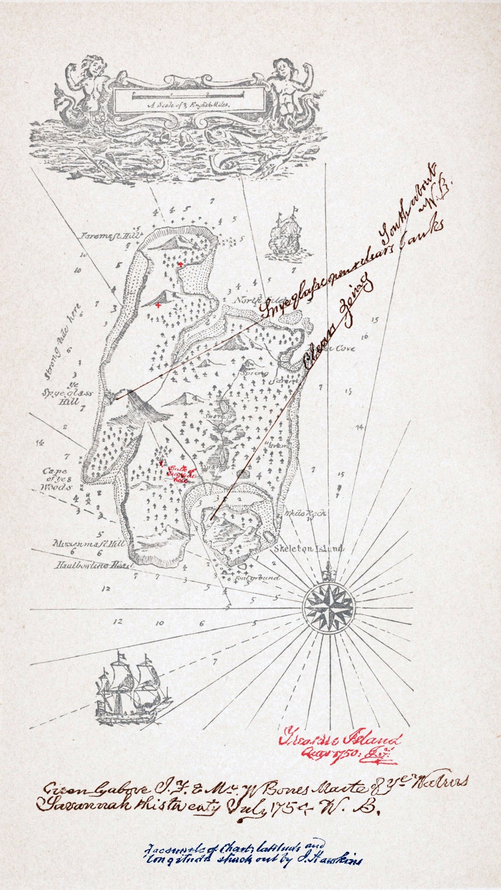
Treasure Island appeared in book form in 1883. The published map gives readers a coastline, hills, anchorages, a compass rose, and a scale. Labels such as Spy Glass Hill and Skeleton Island sound like promises of events still to come. The chart’s appearance also belongs to the story: it resembles a document someone might guard, conceal, or steal.
Robert Louis Stevenson. Public domain. Source and rights record. Resized for web display; no content alteration.

There is an important qualification. This is the published map reproduced from a later nineteenth-century edition, not the lost original drawing that first inspired Stevenson. In his essay, he explained that he sent the manuscript and map to the publisher but was subsequently told the map had not arrived. He then had to reconstruct the island from the geographical details already embedded in his book.
The replacement was drawn in his father’s office. Stevenson credited his father with imitating Captain Flint’s signature and Billy Bones’s sailing directions. Those handwritten marks help make the chart feel like an artifact from the adventure, but their fictional origin should not be confused with an authentic pirate document.
Geography creates consequences
An island is an especially effective setting for a story about competing groups. Its shores limit movement; a vessel can become a means of escape or an object of conflict. Woods and hills interrupt lines of sight. A landing place and a defensible position offer different advantages.
In the novel itself, information about the island is unevenly distributed. The map is valuable because possessing knowledge of the land can influence what happens there. Readers share some of that knowledge through the printed chart, while the characters encounter terrain under pressure and with incomplete information.
This is where an imaginary map borrows the authority of a real one. A scale and compass rose suggest a place with measurable distances and consistent directions. They encourage the reader to believe that a journey takes time and that a hill will remain in the same place when the narrative returns to it.
Stevenson made that expectation explicit in his essay: an author should know the countryside, real or invented, well enough to avoid geographical contradictions. The map therefore serves two audiences. It guides the reader’s imagination and gives the writer a framework that the plot must respect.
Hardy’s country between fact and fiction
Hardy’s Wessex starts from a different relationship with the ground. His literary region draws on southern and southwestern England, but it is not an administrative territory with an official boundary. Real geographical features coexist with fictional place names and settings adapted for particular stories.
In the preface to Far from the Madding Crowd, Hardy explained that he adopted the historical name Wessex to give unity to the countryside in which his novels were set. He traced that use to the novel’s appearance in 1874. The old name provided a regional frame larger than a single county, while the society he described belonged to a much later world of railways, agricultural machinery, schools, and workhouses.
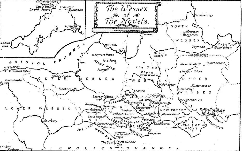
The 1895 map below makes that frame visible. Its title, The Wessex of the Novels, identifies the kind of geography it presents. Recognizable coastlines and landmarks sit alongside names associated with Hardy’s fictional world. It is a guide to the novels’ setting, rather than evidence that a government administered this territory under these labels.
Henry Macbeth-Raeburn. Public domain. Source and rights record. Resized for web display; no content alteration.

The mixture is deliberate. It allows readers to recognize a region without requiring every incident to correspond to an identifiable household or field. The map offers continuity between books, but it does not turn invented characters into historical residents.
Land as work, property, and opportunity
The country in Far from the Madding Crowd is not an empty pastoral backdrop. Bathsheba Everdene’s farm connects ownership with decisions about workers, crops, livestock, and money. Gabriel Oak’s skills have practical value because the farm’s survival depends on knowledge and timely labor.
The storm episode makes those connections particularly clear. Hay and grain exposed to the weather represent work already performed and wealth that could be lost. Protecting them is an urgent physical task, while the decisions surrounding that task reveal differences in responsibility. Weather becomes a social event because its consequences fall on people whose positions and resources are unequal.
These are interpretations of the novel, not statistics about all Victorian farms. Fiction can make the relationship between landscape and livelihood emotionally understandable, but it cannot by itself establish how common an arrangement was or how every landowner behaved. Historical claims need documentary evidence beyond the experiences of invented characters.
That distinction keeps a literary landscape useful. A reader can learn to notice work, distance, dependence, and authority without mistaking a novelist’s selected events for a representative survey of an entire society.
When several places become one
Hardy also described the adjustments that fiction could require. In the preface to The Return of the Native, he explained that Egdon Heath combined or represented a number of real heaths. A later postscript warned readers searching for the scenery that some features resembling those in the novel lay several miles away from the story’s central setting.
That warning is helpful for anyone tempted to treat a literary map as a precise field guide. A writer may bring scattered characteristics together to create a coherent scene. The resulting setting can communicate the character of a landscape even when no single spot contains every detail in the book.
The same caution applies to photographs used to illustrate literature. A picture of real heathland may provide context for Hardy’s terrain, but it should not automatically be labeled as the exact location of a fictional event. A map reproduced from an identified edition can make the relationship clearer than an attractive photograph with an uncertain claim attached.
Reading with a map beside the book
Literary maps are most rewarding when read as part of the work’s construction. Notice what receives a name, where paths connect, and which obstacles separate people. Consider what a character can see from one position and what remains hidden beyond a ridge or shoreline.
Then ask what kind of document the map is pretending to be. Stevenson’s chart belongs to a treasure hunt and turns geographical knowledge into something worth fighting over. Hardy’s regional map gives separate stories a shared countryside and encourages readers to see relationships among towns, farms, and journeys.
Both bring land into the foreground. The places differ in how much they owe to real geography, but neither works simply as decoration. They help make events plausible and human choices understandable. A map beside a novel can therefore offer more than directions: it can show how a story’s world holds together, and why the ground beneath its characters matters.
Sources and further reading
- Robert Louis Stevenson, Essays in the Art of Writing, including “My First Book: ‘Treasure Island’,” for his account of the original and replacement maps.
- Stevenson, Treasure Island, available through Project Gutenberg.
- Thomas Hardy, Far from the Madding Crowd, including the author’s preface and the farm and storm episodes discussed here.
- Hardy, The Return of the Native, especially the preface and 1912 postscript explaining Egdon Heath’s composite geography.
- 1895 map: The Wessex of the Novels, with edition information and public-domain rights record.