
Land & Society
Who Names a Place? The History Behind Names on Maps
A place name helps us find a location, but it also records a human decision. Historical NASA maps and geographic names records reveal the layers of memory behind familiar labels.
On This Page
Two maps of Florida’s space coast can seem to disagree without either being mistaken. On one, the launch facilities stand beside Cape Kennedy. On another, they stand beside Cape Canaveral. Kennedy Space Center appears on both. The shoreline has not performed a disappearing act; the names have different histories, and they refer to different things.
A place name looks modest on the page, often only a few letters squeezed between a road and a river. Yet it can carry a description of the landscape, a memory of someone who lived there, or a government’s decision about what deserves recognition. Names help people find their way. They also reveal how communities understand the land they occupy.
Understanding those two functions makes an old map more interesting. Instead of asking only where a label belongs, we can ask who used it, what it described, and why another name eventually appeared in its place.
Making names dependable
Imagine assembling a map from several surveys. One source calls a stream Mill Creek; another uses a different spelling; a third applies the same name to a nearby tributary. Even accurate measurements will not prevent confusion if the names cannot be reconciled. A label needs an identifiable feature as well as an accepted spelling.
The United States Board on Geographic Names, usually abbreviated BGN, was created in 1890 and established in its present statutory form in 1947. Its purpose is to maintain consistent geographic names across the federal government. The board’s history connects that work to the conflicting names and spellings encountered by surveyors, scientists, and mapmakers during the nineteenth century.
That responsibility is more specific than choosing every name Americans use. Federal feature names, municipal street names, a business’s trading name, and an affectionate neighborhood nickname belong to different systems of authority and custom. An official decision can standardize federal maps without immediately replacing the words used in conversation.
The distinction matters because consistency and cultural significance answer different questions. A standardized name helps agencies exchange information. It does not, by itself, explain the name’s origin or establish that everyone in the surrounding community prefers it.
A cape, a city, and a space center
Cape Canaveral offers a particularly clear example. The geographic cape was called Cape Kennedy during the period from 1963 to 1973. NASA’s launch operations center was also renamed for President John F. Kennedy in 1963, following his assassination. Those were related acts of commemoration, but the physical feature and the NASA institution remained distinct.
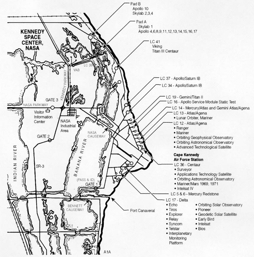
The older map below places Kennedy Space Center on Merritt Island, west of the cape, while identifying Cape Kennedy Air Force Station to the east. Its labels preserve the terminology of the period. They should not be read as a list of current organizations or operating launch pads.
NASA. Public domain. Source and rights record. Resized for web display; no content alteration.

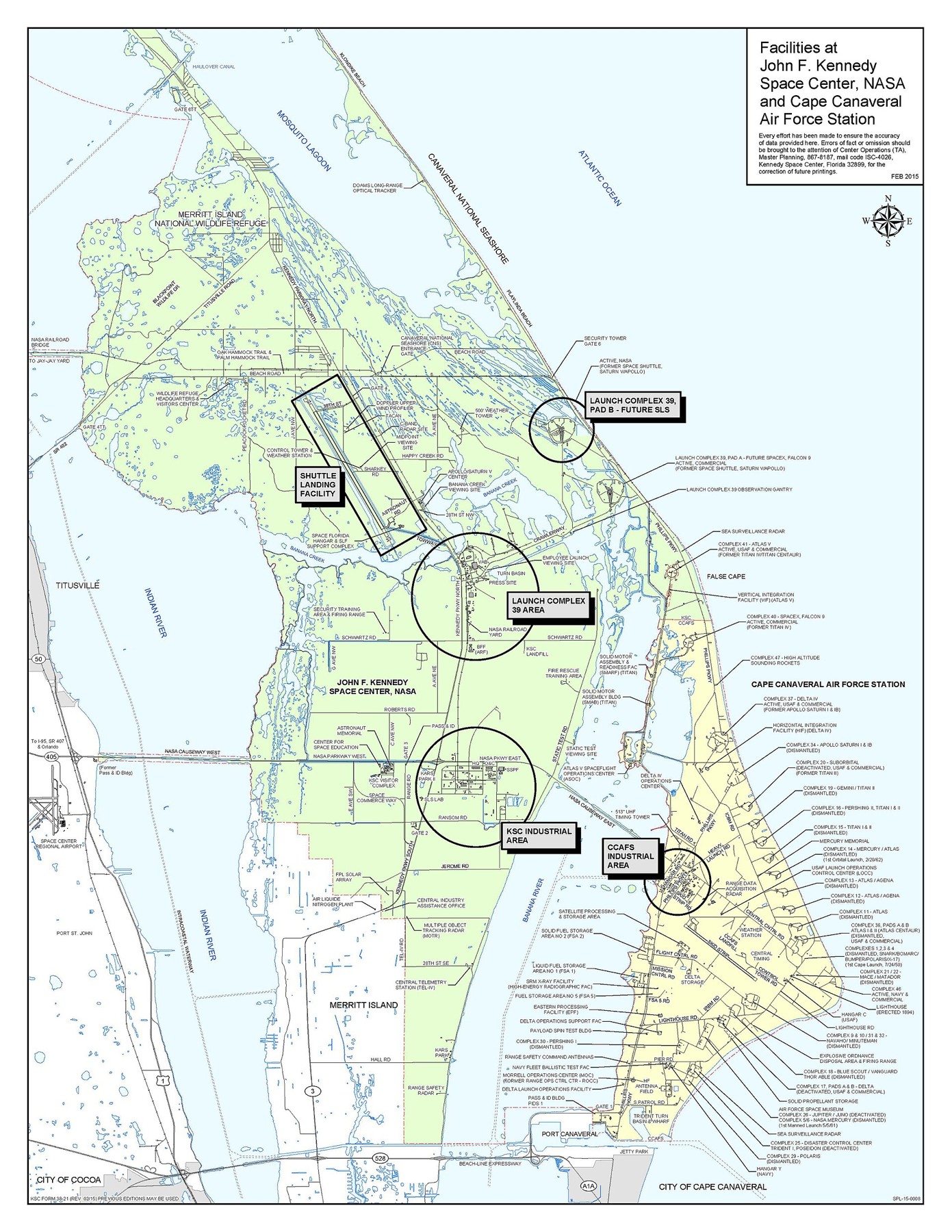
In 1973, the geographic cape’s name returned to Cape Canaveral. NASA’s own historical chronology records Florida’s legislative action restoring the name that May. Kennedy Space Center retained its name. The later map consequently shows both Kennedy Space Center and Cape Canaveral Air Force Station, along with the city of Cape Canaveral farther south.
NASA/Kennedy Space Center. Public domain. Source and rights record. Resized for web display; no content alteration.
.jpg)
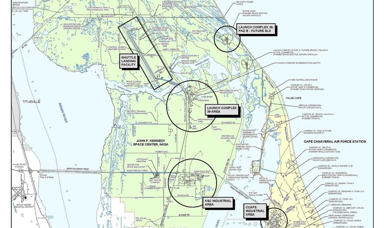
This is not a puzzle resolved by choosing one label and crossing out all the others. The cape, the city, the military installation, and the NASA center are separate geographic or institutional subjects. Their names can change on different schedules. The 2015 map is itself now a historical document; the station name printed on it belongs to that edition, rather than guaranteeing present-day terminology.
For anyone reading launch histories, the lesson is practical. A contemporary account mentioning Cape Kennedy need not describe a different coast from an account mentioning Cape Canaveral. Dates and the exact subject of the name resolve the apparent contradiction.
The record behind the label
The Geographic Names Information System, or GNIS, is a useful starting point for investigating names in the United States. Maintained through the US Geological Survey’s geographic names work, it connects official names with locations and feature information. Records can also include known variant names, historical notes, and relevant BGN decision dates.
A variant name is a clue worth following. It may help connect an older document with a feature identified differently on a modern map. It does not automatically prove that the older name was the earliest, the only locally accepted form, or the one that should be restored.
Locations matter just as much as spelling. A town and a nearby stream can share a name while remaining separate records. Conversely, two accounts may use different words for the same feature. Comparing the feature type, coordinates, surrounding landmarks, and date is more reliable than treating a matching phrase as sufficient identification.
There is also a limit to what a name establishes. Calling a ridge after a family does not demonstrate that the family owned every slope beneath it. A geographic names record is not a deed, a parcel survey, or a judgment about title. Those questions require their own evidence.
Names that live beyond the map
Official maps preserve only part of a landscape’s vocabulary. Families, fishing communities, farmers, and Indigenous nations can maintain names through speech and practice as well as written records. A name’s absence from a particular printed map does not establish that nobody used it.
This is especially important when discussing Indigenous languages. A word copied from an old account may have been misspelled, misunderstood, or applied outside the community associated with it. An appealing translation repeated on tourism websites should be treated as a claim to investigate, rather than a substitute for linguistic and cultural knowledge.
The BGN’s cultural sensitivity guidance advises people proposing names intended to honor Native Americans to work with Tribal leaders, historic preservation officers, linguists, or other appropriate experts. That approach recognizes that respectful naming depends on the people and language involved, not simply on a proponent’s intentions.
The broader historical principle is similar. The communities connected to a place are sources of knowledge, not decorative additions to a finished explanation. Oral accounts and documentary records can illuminate different parts of a name’s history; differences between them deserve investigation rather than an automatic assumption that one is worthless.
Changing a familiar word
A proposed name change involves more than replacing a sign. Maps, emergency records, agency databases, publications, and daily habits may all carry the existing name. The advantages of a change therefore have to be considered alongside the confusion that a poorly explained transition could create.
The BGN’s proposal guidance emphasizes local use and acceptance and calls for a compelling reason to change an existing name. Its process considers evidence and recommendations from relevant governments and agencies. These are procedures for federal geographic usage; they are not a universal rule for every naming decision a town, institution, or property owner might make.
For historical readers, the most useful habit is to keep the earlier name visible in the explanation. Saying that a place was known by a different name at a particular time allows readers to understand the original source without mistaking its language for current usage. It also avoids silently rewriting a document to make it resemble a modern map.
Reading the landscape’s vocabulary
An old map rewards a second look when its names are treated as evidence. Ask what each label identifies, when the map was made, and which authority or community supplied the terminology. Then compare it with another edition, an archival record, or a locally informed account.
Sometimes the result is a simple spelling correction. Sometimes it reveals a commemorative decision, an institutional change, or a history that the neatness of the printed map concealed. In each case, the name connects geography with human choices.
Cape Canaveral and Kennedy Space Center demonstrate that connection without requiring the reader to pick a single word for an entire region. A place can contain several named things and several layers of memory. Learning to distinguish them makes the map more dependable, and the landscape behind it more understandable.
Sources and further reading
- US Board on Geographic Names: history and responsibilities.
- USGS: Geographic Names Information System, including the Domestic Names search link.
- BGN: guidance on name proposals and cultural sensitivity for Native American names.
- NASA: Kennedy Space Center history and fiscal year 2000 annual report, whose historical chronology records the 1973 restoration of the cape’s name.