
Exploration & Places
Living Across the Line: The Unusual Geography of Point Roberts
Point Roberts is part of Washington, but its road connection runs through Canada. Its history and daily geography reveal how an international boundary reshapes a small community.
On This Page
- 01 — Introduction
- 02 — A peninsula divided by a parallel
- 03 — Diplomacy selected the line
- 04 — Turning the agreement into a boundary on the ground
- 05 — Another geography came before the boundary
- 06 — The land route makes ordinary errands international
- 07 — Water does not stop at a national line
- 08 — A small place with a large lesson
- 09 — Sources and further reading
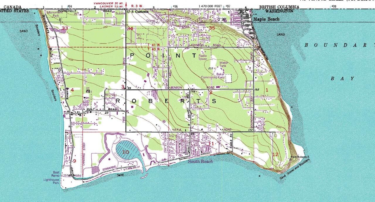
Point Roberts belongs to Washington State, but a road journey from there to the rest of Washington passes through Canada. The explanation is easy to see on a map: a peninsula extends south across the international boundary, placing its tip in the United States while its land connection lies in British Columbia.
The result is more than a geographical curiosity. It affects routes to services, the movement of goods, and the relationship between nearby communities. Point Roberts shows how a line that is simple at continental scale can produce a complicated arrangement at neighborhood scale.
A peninsula divided by a parallel
Point Roberts occupies the southern tip of the Tsawwassen peninsula. Water lies on three sides; the land to its north is Canadian. It is therefore not an island, even though its separation from the rest of its country can resemble island life in some practical respects.
The cropped US Geological Survey map below makes the relationship visible. Its northern edge identifies Canada and the United States along the boundary. Roads, contours, shorelines, and developed areas sit within the small American part of the peninsula. It is a historical map, cataloged as 1994, and should be read for geography rather than current facilities or road conditions.
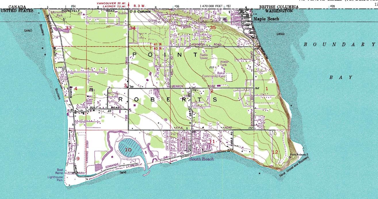
United States Geological Survey. Public domain. Source and rights record. Resized for web display; no content alteration.

“Exclave” describes territory separated from the main portion of its country. Point Roberts is also called a pene-exclave because it remains accessible directly from the United States by water or air while its practical land route passes through another country. The terminology is less important than the relationship it describes: national membership and road connectivity do not necessarily coincide.
Diplomacy selected the line
The Oregon Treaty of 1846 settled the major territorial division between the United States and Great Britain in this part of the Pacific Northwest. It extended the boundary along the 49th parallel westward from the Rocky Mountains, with provisions that left the whole of Vancouver Island on the British side.
The US State Department’s historical overview places that agreement within years of competing claims and negotiation. The treaty was signed on June 15, 1846, and the Senate ratified it on June 18. Those are different milestones, not conflicting dates for the same action.
Point Roberts fell south of the selected parallel. Its unusual position followed from the boundary’s relationship to the peninsula. Describing this as a surveyor’s mistake substitutes a convenient anecdote for the diplomatic decision. Survey crews had to establish and mark the agreed line; they did not independently choose which country should receive the southern tip.
Turning the agreement into a boundary on the ground
An international agreement supplies a legal description. Surveying and demarcation connect that description to physical positions and monuments. Maintaining the result is an ongoing responsibility, rather than a task completed once and forgotten.
The International Boundary Commission describes its work inspecting and maintaining monuments, reference points, survey control, and the cleared boundary vista. Its maps and coordinate resources provide a record more authoritative for the international line than an approximate boundary drawn on an ordinary travel map.
A photograph cataloged by the Library of Congress as 1861 shows the Point Roberts monument bearing the treaty’s 1846 date. The inscription commemorates the agreement; it does not date the photograph. The distinction is small but important when a historical image is used as evidence.
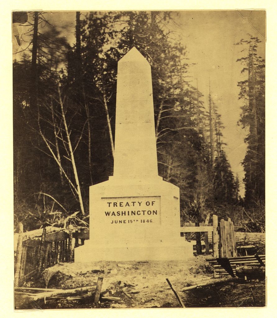
Photographer unrecorded; Library of Congress, Prints and Photographs Division. Public domain. Source and rights record. Resized for web display; no content alteration.

A monument also differs from a border crossing. The former marks the boundary. The latter is a designated place where movement across it is administered. A line can be clearly marked without making every point along it an authorized route between countries.
Another geography came before the boundary
The international division crossed an Indigenous landscape. Tsawwassen First Nation’s account of its traditional territory includes the Point Roberts peninsula and describes a broader network of land, waters, resources, and cultural relationships.
That account changes the scale of the story. The peninsula was not waiting without a history for British and American negotiators to classify it. Fishing, travel, trade, and community relationships connected places that the later national line separated administratively.
Traditional territory and present-day treaty settlement lands are different concepts. Recognizing the former does not mean every place within it has the same contemporary jurisdiction. It does mean that a complete history of the boundary must include people whose relationship to the area did not begin with the 1846 agreement.
The land route makes ordinary errands international
To travel by road between Point Roberts and the main portion of Washington, a person crosses into British Columbia and later crosses back into the United States. A return journey repeats the arrangement. Short geographical separation therefore produces additional administrative steps that a map’s straight-line distance does not capture.
The distinction between proximity and access matters for households and businesses. A service can be nearby across the border but governed by another country’s institutions. A service within the same state can require a longer route involving international crossings. Distance is only one component of accessibility.
Education supplies a concrete example. The Blaine School District operates its main schools in Blaine and a separate primary school in Point Roberts. The district’s geographical arrangement reflects the community’s separation. Local accounts describe the repeated cross-border journeys of older students attending school in Blaine, illustrating how the line becomes part of a weekly routine rather than merely an occasional travel event.
Changes in border procedures and service arrangements consequently have a close relationship to everyday life. The same geographical separation that intrigues a map reader can shape a family’s school day or an ordinary shopping trip.
Water does not stop at a national line
Not all cross-border relationships involve people. Drainage connects the peninsula’s northern and southern portions through the physical landscape. Whatcom County’s Point Roberts drainage study identifies high water tables, flooding, and possible influences from development and maintenance practices along the Canadian side of the boundary.
The study offers a useful example of why political maps and environmental maps need to be read together. Water follows slopes, channels, and soil conditions. Management responsibilities follow jurisdictions and property arrangements. Solving a local problem requires understanding both patterns.
The county’s Point Roberts subarea planning records likewise show that the community is a place with planning needs, not merely a cartographic oddity. Housing, circulation, public facilities, and development decisions must work within its particular location.
A small place with a large lesson
Point Roberts makes the consequences of boundaries unusually visible. A treaty line organizes national territory. A survey gives that line physical evidence. Residents then build everyday routines around the resulting arrangement, while water, cultural relationships, and regional connections continue across it.
The town’s interest lies in that combination. It is American territory, part of a continuous peninsula, and a community whose land route to its own state runs through Canada. Understanding all three descriptions gives a richer picture than calling it an island or a mistake. The map is the beginning of the story; life on either side supplies the rest.
Sources and further reading
- US State Department: the Oregon boundary agreement of 1846.
- International Boundary Commission: boundary maintenance and official maps and coordinates.
- Tsawwassen First Nation: our nation and traditional territory.
- Blaine School District and Point Roberts community information.
- Whatcom County: drainage study and subarea plans.