

Maps & Mapping
The Babylonian Map of the World: A Small Tablet with a Vast Horizon
A broken clay tablet places Babylon within a circular world, bringing real geography and inherited stories together in one extraordinary ancient map.
On This Page
The world fits into a circle, and Babylon occupies a conspicuous place inside it. Beyond the circle lies a band of water; beyond the water, pointed regions push toward the edge of a broken clay tablet. The image is small enough to overlook in a museum case. Its ambition is difficult to miss.
Known as the Babylonian Map of the World, this object asks a surprisingly familiar question: what belongs in a picture of the world, and what makes the picture meaningful? Its answer combines recognizable places with a written account of distant, extraordinary regions. Reading it well means resisting the temptation to grade it as an unsuccessful modern atlas.

Credit: Osama Shukir Muhammed Amin FRCP(Glasg). CC BY-SA 4.0; resized without cropping.
A world preserved in clay
The British Museum catalogue dates the tablet to approximately the sixth century BCE. Its registration number is 1882,0714.509, and its museum number is 92687. The museum associates its findspot with Abu Habba, ancient Sippar, in present-day Iraq. These identifiers matter: they tie the widely reproduced picture to a particular archaeological object rather than to a modern reconstruction of an ancient idea.
The surviving tablet is about 4.8 inches (12.2 centimeters) high and 3.2 inches (8.2 centimeters) wide. Those dimensions make the scale of its conception almost startling. A reader does not confront a wall-sized panorama. The world has been organized on a piece of clay small enough to hold in one hand, with room reserved for writing as well as drawing.
There is no securely identified creator whose life can be reconstructed from the surviving evidence used here. That limitation should stay visible. The map was produced within a literate Mesopotamian tradition, but assigning it to a famous ruler, a named traveler, or an otherwise undocumented royal mapping office would add a story the object does not supply.
Learning to make marks that carried meaning
The writing is cuneiform, a script whose name refers to its wedge-shaped signs. Clay was a working medium for records, letters, literature, and learned texts in Mesopotamia. As the Metropolitan Museum explains in its account of the origins of writing, the uses of the script had expanded well beyond early economic bookkeeping long before this map was made.
A separate student exercise tablet in the Met’s collection offers a useful glimpse of the training behind that written culture. It belongs to the Old Babylonian period, many centuries earlier than the world map. The repeated signs on it record an exercise, not a map. Its relevance is the patient acquisition of a skill: signs had to be learned before they could communicate a complex description of places.
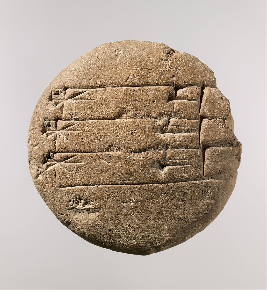
Credit: The Metropolitan Museum of Art. Public-domain Open Access image.
The comparison also guards against a common misunderstanding. To a reader unfamiliar with the script, both objects may initially look like patterned surfaces. To trained readers, those patterns conveyed language. On the world tablet, written labels and the diagram work together. Looking only at the circle removes an important part of the evidence.
Reading the circle
In the British Museum’s accompanying description, Babylon is the rectangle in the upper half of the central circle. Other places are named, including Assyria and Elam. The encircling waterway is translated there as “Salt-Sea.” The map therefore has identifiable geographical content, even though its arrangement differs radically from the outlines familiar in a modern world map.
The interior and exterior have different visual roles. Inside, places can be related to one another within a bounded space. Outside, surviving triangular projections suggest regions beyond the surrounding water. The museum considers eight such regions to have been present originally. Because the tablet is damaged, that reconstruction is an interpretation of incomplete evidence, not a count of eight intact triangles available to inspect today.
The accompanying text describes remote regions and includes extraordinary beings and heroic traditions. Its incomplete condition prevents a perfectly continuous reading. That mixture is central to the object’s interest. Known places and inherited accounts of the distant world occupy the same intellectual landscape, rather than being separated into a geographical atlas and a book of stories.
The city at the center of attention
Babylon was a real urban center with a political and cultural importance that outlasted individual rulers. UNESCO’s account of the archaeological site identifies it as the capital of the Neo-Babylonian Empire between 626 and 539 BCE. Temples, palaces, defensive works, and the remains of its urban organization give that historical city a material presence beyond the tablet’s compact rectangle.

Credit: Osama Shukir Muhammed Amin FRCP(Glasg). CC BY-SA 4.0.
Placing Babylon prominently is consequently meaningful, but it does not settle every question about the tablet’s purpose. A visual center can be a point of orientation, a claim about importance, or part of a larger narrative. It is reasonable to see the map as expressing a Babylonian perspective. It is less reasonable to pretend that its intended audience and every stage of its use are known.
Scholars continue to examine that distinction. In the abstract of “A Land with No Borders,” Paul Delnero argues that treating the map only as a static, ideological picture overlooks the ways it connects real and mythological landscapes with the Mesopotamian past and present. His interpretation is a reminder that even an apparently simple diagram can support more than one historically informed reading.
What the surviving map can tell us
The surviving object does not establish that this particular map circulated widely, directed journeys, or changed government policy. Its importance to us is not evidence that it was equally famous in antiquity. Nor can one diagram stand in for everything every Babylonian believed about the earth. Survival is selective; a durable artifact can become representative simply because so much else has disappeared.
What it does preserve is a deliberate act of organization. Someone selected places, drew relationships, enclosed a central region, and made the distant world legible through image and text. That is a substantial achievement without attaching a modern surveying purpose to it. The tablet records how geographical knowledge could be made to share space with cultural memory.
The Babylonian Map of the World remains compelling because its small surface holds a large human undertaking: arranging the familiar and the unknown into a world a reader can contemplate. Its damaged edges leave questions open, but its central lesson survives clearly. A map reveals the priorities of the people who made it as well as the places they chose to show.
Sources and further reading
- British Museum: object 1882,0714.509 — catalogue, dating, identifiers, and description.
- British Museum on Google Arts & Culture — dimensions and explanation of the map and surrounding regions.
- The Met: student exercise tablet 86.11.251 and The Origins of Writing — the separate illustrated object and scribal context.
- UNESCO: Babylon — the historical city and issues of archaeological authenticity.
- Paul Delnero, “A Land with No Borders” — an alternative scholarly interpretation; the linked abstract is accessible, while full-text access may vary.