

Exploration & Navigation
James Cook: The Surveyor Before the Famous Voyages
Before the Pacific made him famous, James Cook spent years charting Newfoundland. Those coastal surveys reveal the patient mapmaker behind the celebrated captain.
On This Page
In Nathaniel Dance-Holland’s portrait, James Cook sits in a naval uniform with a chart across his knee. His hand points toward the eastern coast of Australia. It is the image of a man already associated with voyages that had carried Britain’s ships across the Pacific.
Look past the uniform, though, and the chart tells another story. Cook’s reputation began with the work of a surveyor. Before the Endeavour sailed for Tahiti, he spent years turning the coasts of Newfoundland into maps that other mariners could trust. The cold waters of the North Atlantic were a proving ground for the captain who would become a household name.
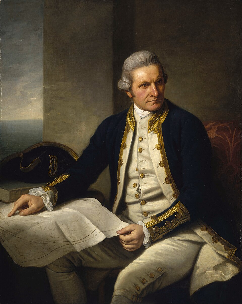
Nathaniel Dance-Holland / National Maritime Museum, Greenwich, via Wikimedia Commons. Public domain. Source.

A Seaman Learns to See a Coast
Cook was born in Yorkshire in 1728. His early maritime career began in the coastal coal trade, an apprenticeship in the working world of ships rather than the drawing rooms of naval patronage. He volunteered for the Royal Navy in 1755 and rose through roles that placed navigation among his everyday responsibilities.
His North American service gave those abilities a larger stage. During the years he was based in Halifax, from 1758 to 1762, he helped compile charts for Quebec and Nova Scotia. Parks Canada identifies this period as an important part of his training, when he learned surveying methods that would underpin the work to come.
A coastline looks deceptively straightforward on a finished sheet. From a ship, it changes with distance and angle. A headland can hide a bay; offshore rocks can be difficult to distinguish from open water. The surveyor’s task was to turn those changing views into a record another crew could consult under entirely different conditions.
Five Years Around Newfoundland
From 1763 to 1767, Cook directed surveys around much of Newfoundland’s coast. The assignment asked for close attention to a large island with an intricate shoreline. The finished work needed to describe the coast and the water beside it, bringing the shape of the land together with depths and hazards that mattered to shipping.
The practical stakes were immediate. A chart could help a vessel find an approach to a harbor, recognize a feature, or avoid a rock. Surveying belonged to the everyday business of fishing, trade, and naval operations. Its value would be tested whenever someone used the printed information at sea.
Cook’s work also belonged to a wider effort. Michael Lane continued surveying in the region, and other contributors appear in the records of the charts. A general map of Newfoundland published by Thomas Jefferys in 1775 credits Cook, Lane, and others. It is a handsome reminder that even a celebrated individual’s map has more than one pair of hands behind it.
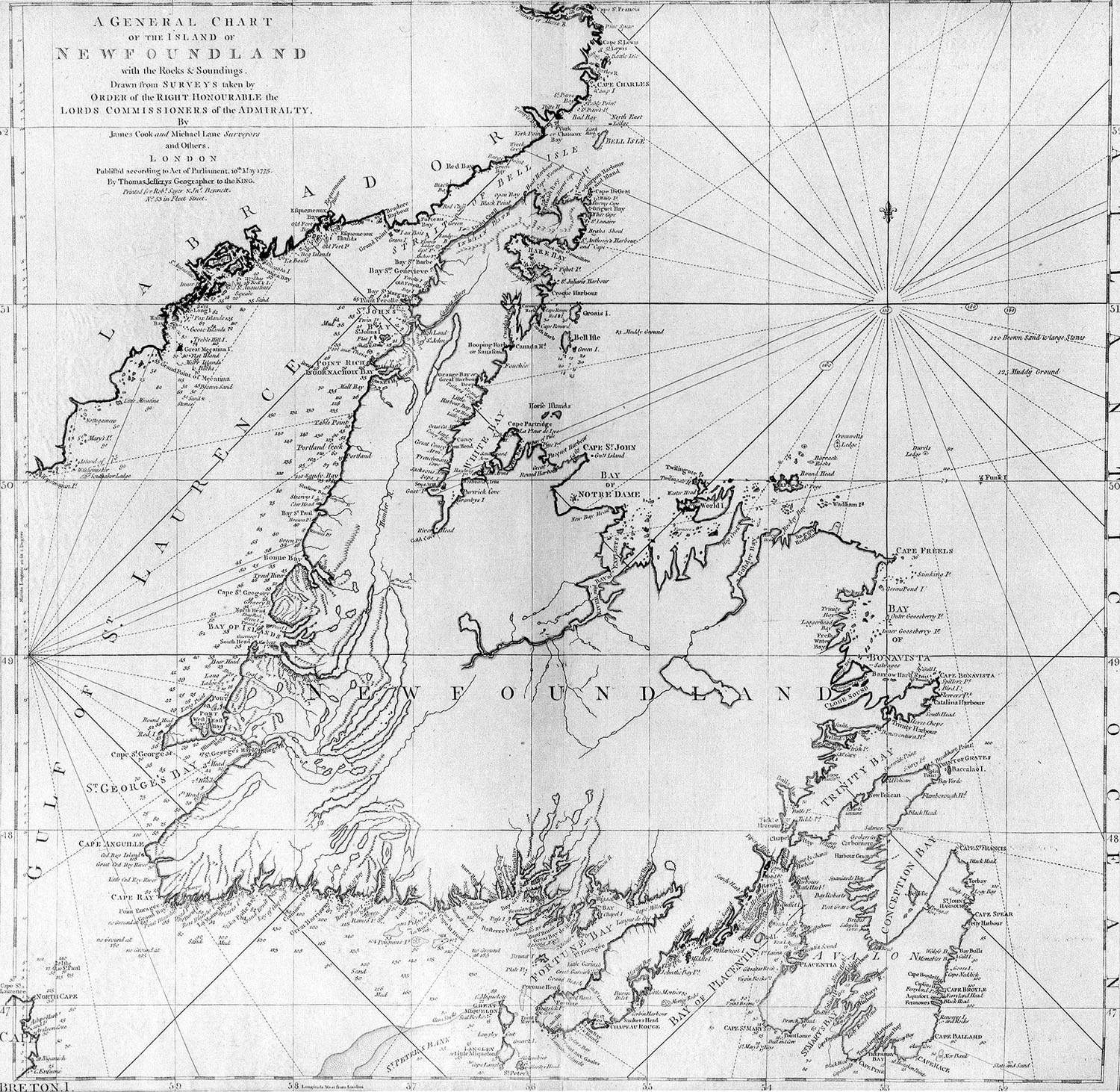
James Cook and Michael Lane; Thomas Jefferys / Centre for Newfoundland Studies, Memorial University, via Wikimedia Commons. Public domain. Source.

The chart repays a leisurely look. Bays interrupt the outline, islands gather around the coast, and small figures record soundings offshore. Its title promises both rocks and depths. The pleasure of the old engraving lies partly in how much patient work is compressed into marks that seem effortless on paper.
An Eclipse Between Surveying Seasons
On August 5, 1766, Cook observed an eclipse of the sun in Newfoundland. The observation was communicated to the Royal Society by John Bevis and published in its Philosophical Transactions the following year. The surviving paper places the future Pacific commander in the smaller, exacting world of a timed astronomical event.
It is a revealing episode because the surveyor’s attention was already reaching beyond the visible shoreline. Celestial observations offered another way to connect a place with the wider world. Cook’s coast work and his astronomical interests belonged to the same expanding set of abilities.
The Royal Society’s record also gives modern readers something more intimate than a retrospective tribute. It preserves a piece of work produced before his great fame. Cook was still building the reputation that would make him an attractive choice for a very different assignment.
The Pacific Opens
In 1768, Cook sailed in the Endeavour for Tahiti to observe the transit of Venus. After that scientific task, his instructions called for further exploration in the Pacific. He charted New Zealand and the eastern coast of Australia, applying skills developed during years of less celebrated service.
The work brought new relationships as well as new charts. Tupaia, a skilled Polynesian navigator from Raiatea, joined the voyage at Tahiti in 1769. As the Natural History Museum explains, he served as guide, interpreter, and diplomat. His knowledge and relationships helped the expedition understand a world that was already navigated and inhabited.
That perspective belongs in any account of Cook. European charts did not make the Pacific a previously empty place. Indigenous people had their own names, routes, histories, and knowledge of the sea. The expedition’s records emerged from encounters between those worlds, with consequences that reached well beyond cartography.
Even a highly accomplished navigator could meet a danger his chart did not show. In June 1770, the Endeavour struck the Great Barrier Reef. The damaged vessel reached what is now called the Endeavour River, where stores and equipment were taken ashore and the ship was careened for repairs.
A print in the National Maritime Museum’s collection depicts that episode. It offers a useful companion to the composed portrait: one shows public reputation, while the other records the practical vulnerability of a wooden ship far from home. Skill mattered enormously, and the sea still had the power to interrupt a voyage.
The Mapmaker Behind the Captain
Cook’s Newfoundland charts remained standard for about a century, according to Parks Canada’s historic designation. That longevity is a remarkable measure of his early work. A survey made before his famous Pacific voyages continued to serve mariners long after the man himself had died.
The portrait’s Australian coastline naturally draws the eye toward the great expeditions. Newfoundland provides another way into the same life: years of repeated observations, coastwise travel, and the preparation of charts intended for other people’s use.
It is an appealing story for anyone who enjoys old maps. Cook’s fame grew around voyages to distant places, but the habits that supported those voyages were formed in the careful business of finding out where things were. The surveyor was there before the celebrated captain—and remained there throughout his travels.
Sources and further reading
Royal Museums Greenwich: Captain James Cook portrait
Royal Museums Greenwich: Captain James Cook research guide
Parks Canada: Captain James Cook historic designation
Royal Museums Greenwich: Newfoundland chart, 1775
Royal Society: Cook’s 1766 eclipse observation
Natural History Museum: On tour with Tupaia
Royal Museums Greenwich: Repairing Cook’s ship in Endeavour River