
Engineering & Infrastructure
Reading Beneath the Surface: What Ground-Penetrating Radar Can Reveal
Ground-penetrating radar makes an ordinary patch of ground a little less opaque. Its reflections offer clues about buried features, with a few surprising rules about what the screen is actually showing.
On This Page
From a distance, a ground-penetrating radar cart can look like an unlikely piece of yard equipment. Someone pushes it across grass or pavement while watching a display. Nothing is dug up, and the ground gives no visible sign that it has contributed any information.
On the screen, however, a line of travel is becoming a record of returning signals. The appeal is immediate: an ordinary surface has begun to offer clues about what lies below.
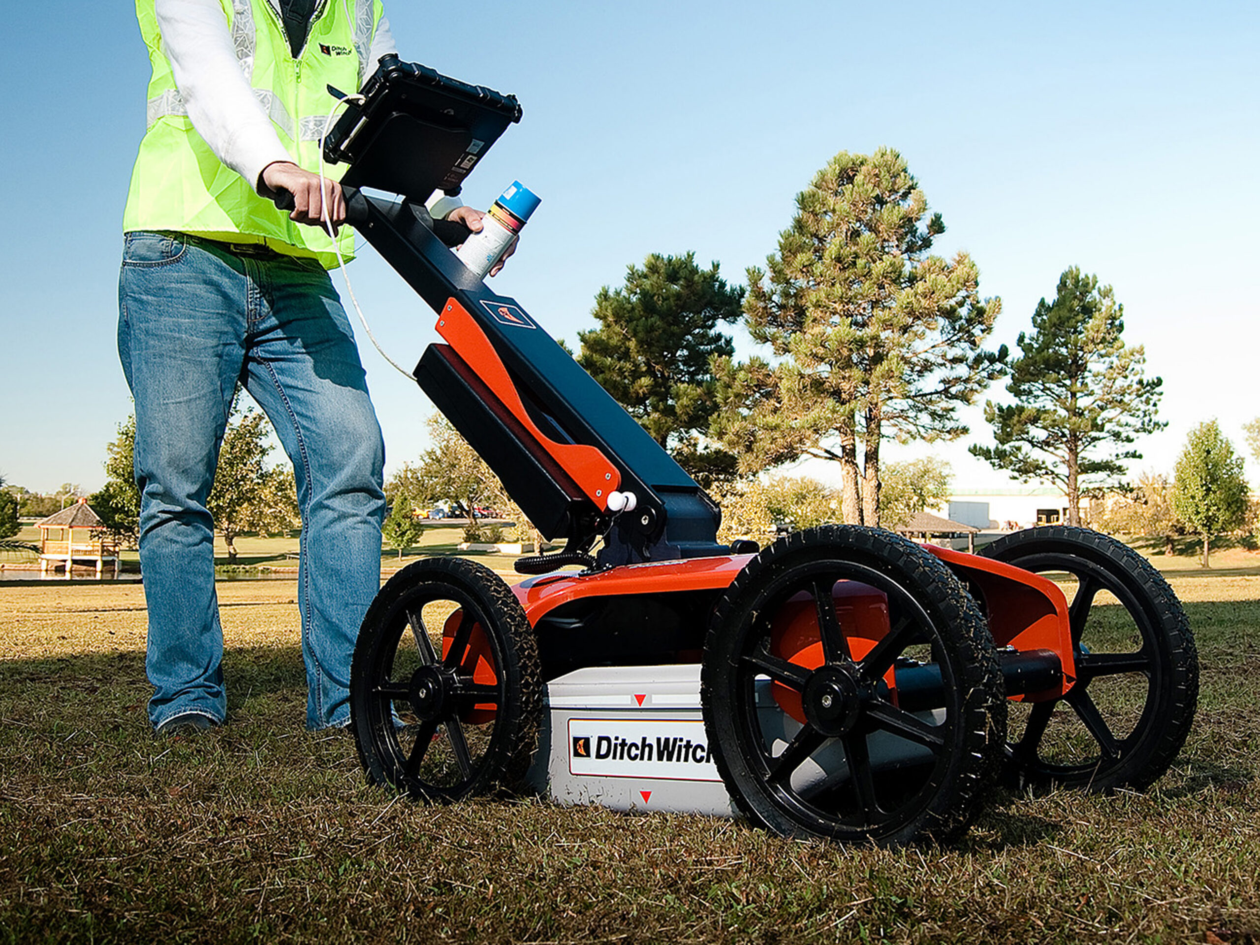
Photo: The Charles Machine Works / Ditch Witch, via Wikimedia Commons. CC BY-SA 2.0; WordPress resized the original.

The radar listens for a change
Ground-penetrating radar, usually called GPR, sends electromagnetic pulses into a material and records returning energy. When a pulse encounters a sufficient contrast in electromagnetic properties, some energy can reflect back toward the receiver.
That contrast might occur at a buried object, a change between materials, or a boundary associated with different moisture conditions. The radar is responding to physical properties, not reading a label that says “pipe,” “void,” or “old foundation.”
This is the first useful adjustment to the popular idea of an underground camera. GPR can provide detailed information, but its observations need interpretation. A reflection is evidence of a contrast; what caused the contrast is the next question.
A curve is not necessarily a curved object
As the antenna moves along a line, the system records successive signal traces. Plotted together, they form a radargram: a section with position along the line on one axis and signal travel time on the other. A depth display requires a relationship between travel time and the wave’s speed through the material.
One of the recognizable patterns is a hyperbola, an upside-down U in a typical radar section. A compact target can produce it because the antenna begins detecting the target before it is directly overhead. The path shortens as the antenna approaches, then lengthens after it passes.
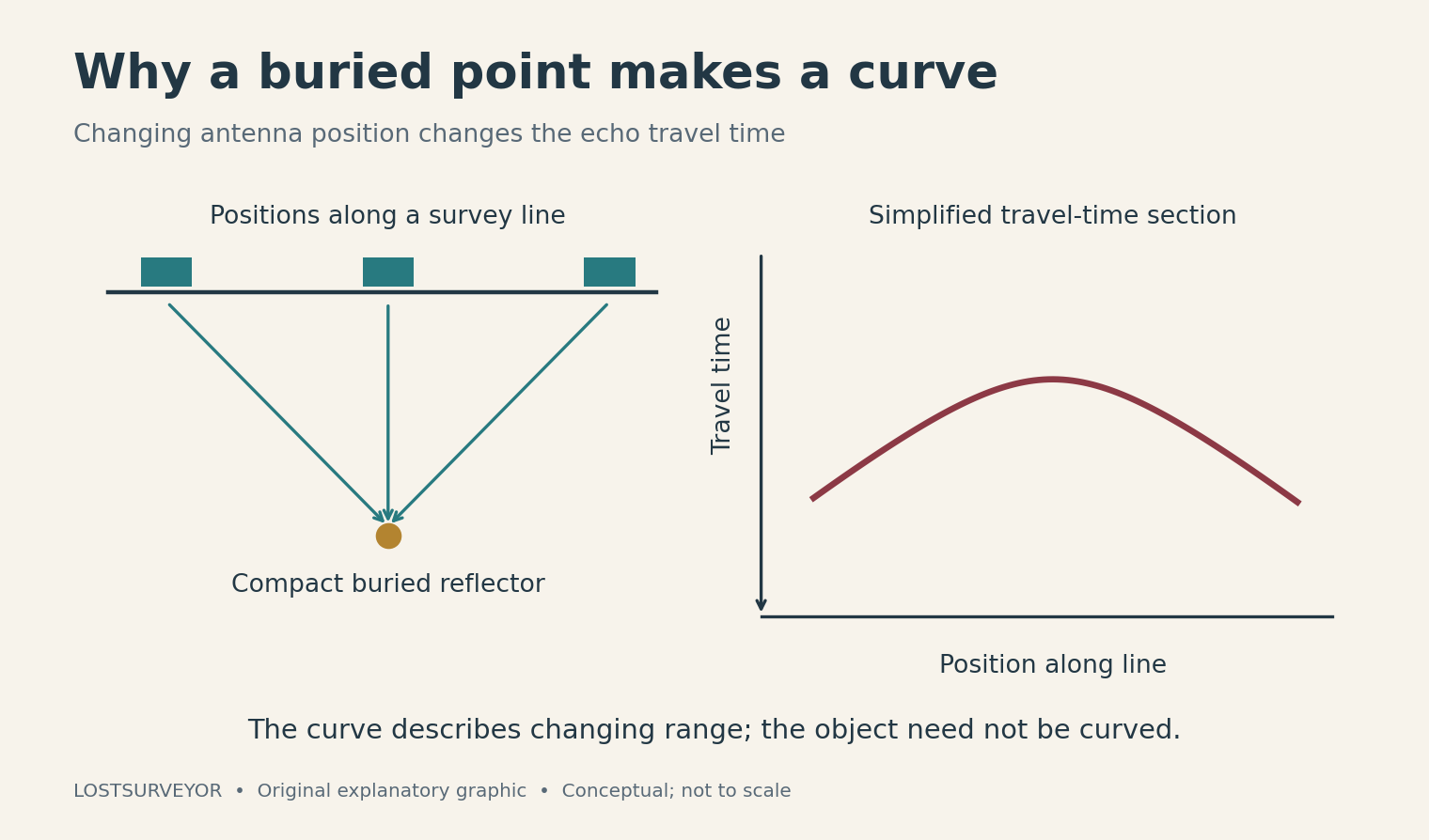
Original explanatory graphic for LostSurveyor. Conceptual; not field data or a scale drawing.
The shortest travel time occurs near the top of the curve in the simplified case. The object does not have to be arched. The curve is largely a story about the changing observation geometry.
I like this detail because it changes how you look at the entire display. The screen is not an excavation wall with the dirt removed. It is a picture of a measurement process, and learning that process makes the patterns much more interesting.
The soil gets a vote
How far radar energy travels depends strongly on the material. Electrically conductive conditions can attenuate the signal, reducing useful penetration. Some clay-rich soils and saline conditions can be difficult, while other settings allow much clearer observations.
A depth claim made without the ground conditions is therefore missing a large part of its meaning. The equipment does not carry one dependable seeing distance from every site to the next. The target’s size, orientation, and contrast also influence whether it can be recognized.
Antenna frequency introduces another tradeoff. Higher-frequency systems can resolve finer detail but generally have shallower useful penetration; lower-frequency systems can investigate deeper under suitable conditions, with coarser detail. The choice reflects the question and the setting, rather than a simple ranking from weak equipment to powerful equipment.
Patterns need context
A set of related survey lines can help trace a feature and separate a persistent pattern from a one-line curiosity. With suitable processing, a grid of observations can also support plan-view slices through selected travel-time or estimated-depth intervals.
Those views can be helpful for seeing relationships across an area. They still inherit the quality of the observations and the assumptions used to interpret them. Converting travel time to depth is especially important: the wave speed in the ground is not automatically the speed of light in empty space.
Above-ground objects and other interference can complicate the record, too. A busy site supplies many potential explanations for a signal. The strongest interpretation is one that considers the setting and can be compared with other evidence, rather than one that happens to resemble the expected object.
The buried clue needs a surface location
For surveying, detecting a feature is only part of the task. Its interpreted location has to be related to the ground and the project. A mark made in the field can be useful, but a durable record needs more than paint that may disappear.
GPR systems can be paired with positioning information, allowing interpreted targets to be associated with coordinates and mapped after collection. That connection makes the observations easier to revisit alongside plans and other spatial records.
Positioning the radar does not remove uncertainty about the radar interpretation. It solves a different part of the problem: where the observation was made and where the interpreted feature belongs. Keeping those two questions distinct makes the finished account more honest and more useful.
A better question about the ground
GPR’s attraction extends beyond utilities. Geologic interfaces, archaeological features, and elements within concrete can all be suitable subjects in the right circumstances. The same pulse-and-reflection idea reaches into several kinds of hidden landscape.
The pleasure is not that the ground suddenly becomes transparent. It is that we can ask it a more informed question. A cart crosses the surface, a pattern appears, and careful interpretation begins turning an unseen feature into something that can be located, discussed, and investigated further.
Sources and further reading
- U.S. EPA: Ground-penetrating radar — The physical contrasts, interpretation, and limits of the method.
- GSSI: What is GPR? — Equipment, antenna frequency, and common data displays.
- Sensors & Software: GPR questions and answers — Travel-time hyperbolas and the role of propagation velocity.
- U.S. EPA: Archived GPR background — Useful background on soil conditions, target properties, and interference.
- GSSI: Integrating GPS with GPR — Connecting interpreted radar features with a persistent spatial record.