

Tools & Technology
The Theodolite: How a Turning Telescope Changed Surveying
How a telescope, two angle circles, and some ingenious checks let surveyors carry measurement across valleys, through national networks, and into the modern total station.
On This Page
- 01 — Introduction
- 02 — What the telescope is actually measuring
- 03 — A name older than the familiar instrument
- 04 — When an angle became part of a national map
- 05 — Technical sidebar: what one second of arc means
- 06 — Smaller instruments, finer readings
- 07 — Why surveyors turn the telescope over
- 08 — Technical sidebar: what reversal can and cannot fix
- 09 — The theodolite inside the total station
- 10 — A line worth keeping
- 11 — Sources and further reading
You can locate a hilltop without measuring a line all the way up the hill. Measure a suitable baseline, observe the directions to the summit from its ends, and geometry does the climbing. The idea is simple enough to draw on a napkin. Making it accurate enough to map a country took generations of instrument makers and surveyors.
The theodolite sits at the center of that story. Its basic job is to measure horizontal and vertical angles: how far to turn, and how far to look up or down. A telescope gives the observer a precise target; graduated circles give that direction a number. From those modest ingredients came an extraordinary reach.
What the telescope is actually measuring
I’ll start with the distinction that makes the rest easier: a direction is one pointing; an angle is the difference between two pointings. Set an instrument over a marked station, sight a reference target, then turn to another target. The change in the horizontal reading is the angle between their directions, as seen in plan. One target can be higher than the other without changing what that horizontal angle means.
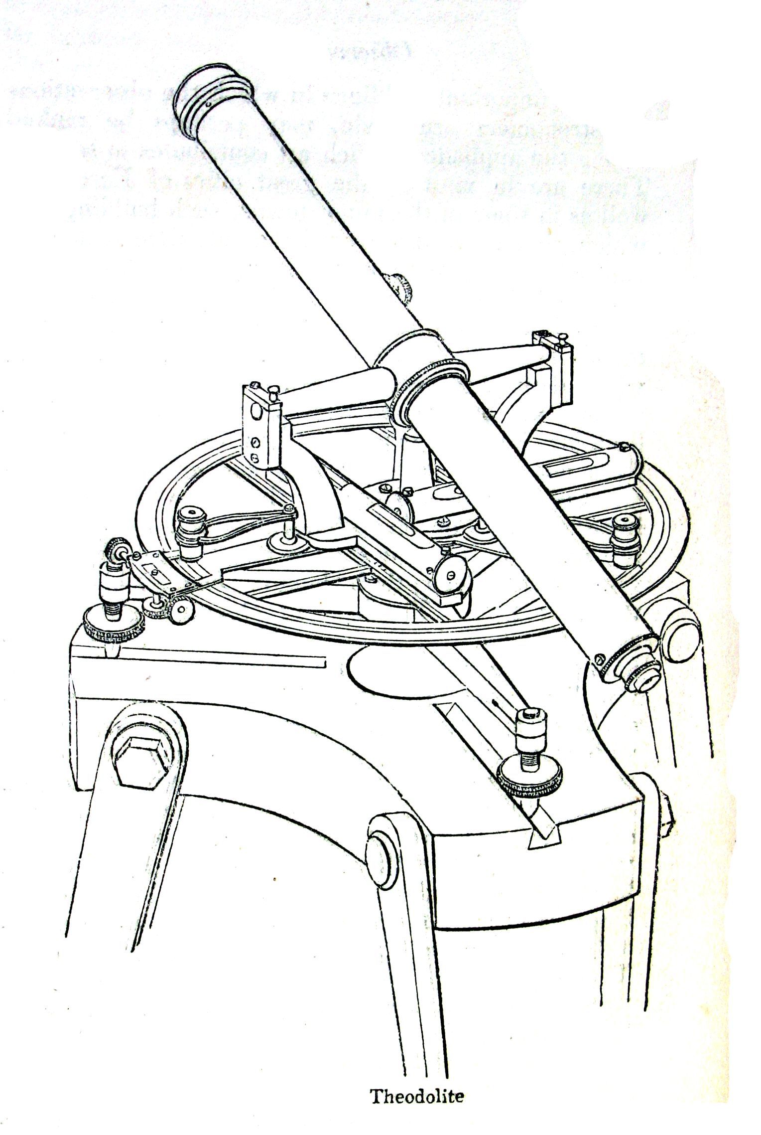
The instrument turns around an upright, or standing, axis. The telescope also tilts around a horizontal axle called the trunnion axis. Its crosshairs define the line of sight. These parts have to agree geometrically: the standing axis should be vertical, the trunnion axis perpendicular to it, and the line of sight perpendicular to the trunnion axis. Tiny departures matter when the target is a long way off.
The vertical circle supplies the other part of the pointing. Some instruments or settings express an elevation angle above the horizontal; others give a zenith angle measured down from the direction overhead. A level sight can therefore read zero or 90 degrees. Before interpreting an old field book, it helps to know which conversation the instrument was having.
Pictorial Gallery of Arts, Charles Knight & Co.; engraver unknown. Public domain. Image source and rights.

A name older than the familiar instrument
The word reaches back to the sixteenth century, before the familiar telescope instrument. Leonard and Thomas Digges’s Pantometria appeared in 1571. A surviving theodolite made by Humfrey Cole in 1574, now at Royal Museums Greenwich, has a divided base plate, a geometrical square, and a compass. The museum identifies its upper sights and scale as a later restoration, a useful warning against treating every part of an old object as original.
Open sights gave surveyors a way to line up a target, but a telescope made a distant detail easier to distinguish and crosshairs made the aiming point more definite. The improvement depended on much more than magnification. Bearings had to let the instrument turn smoothly without wandering; levels had to establish its orientation; scales had to be both accurately divided and readable.
Those scale divisions are easy to overlook. A finely engraved circle can be beautiful and still be wrong. Dividing engines, verniers, and micrometer reading systems addressed different pieces of the problem: placing the marks consistently, then reading fractions of the spaces between them. Better aiming and better reading had to develop together.
When an angle became part of a national map
Jesse Ramsden’s great theodolites show how seriously eighteenth-century surveyors took that challenge. The Science Museum preserves the three-foot (about 0.91-meter) instrument he made in 1791 for the work that became the Principal Triangulation of Great Britain. Its size served a practical purpose: a large circle gave the maker and observer more physical room to divide and read small angles.
There is a pleasantly unromantic detail in the museum’s account. The East India Company had ordered the instrument, but refused Ramsden’s bill. The Board of Ordnance bought it instead. An instrument associated with the beginning of a national survey had first encountered the more familiar problem of getting paid.
Triangulation connected that precision to the landscape. Starting with a measured baseline, surveyors observed angles to a third station and calculated the remaining sides of the triangle. A calculated side could then serve as the starting side for the next triangle. More observations, additional baselines, and connections to other stations let them check and adjust the growing network. On a national scale, the calculations also had to account for Earth’s curved surface.
The United States Coast Survey followed the same broad logic. In 1816–17, Ferdinand Hassler’s early work near New York connected eleven points using two measured baselines and angles observed with a 24-inch (about 61-centimeter) theodolite made by Edward Troughton. The telescope made distant stations accessible to measurement, but crews still had to find suitable sites and arrange clear lines of sight between them. Geometry could cross a valley; it could not see through a hill.
Technical sidebar: what one second of arc means
An angular second is 1/3,600 of a degree. At a distance of one mile (about 1.61 kilometers), a change of one second in direction moves the line sideways by about 0.31 inch (7.8 millimeters). At 100 feet (30.48 meters), it is about 0.006 inch (0.15 millimeter). Those are geometric effects of an angular change, not promises about the accuracy of a surveyed point.
The calculation is distance × tan(angle). It also explains why setup errors deserve attention: a target displaced sideways by 1/8 inch (about 3.2 millimeters) at a distance of 50 feet (15.24 meters) changes the observed direction by about 43 seconds. These illustrative values isolate one effect; they are not a complete error budget.
Smaller instruments, finer readings
The instrument on a working surveyor’s tripod gradually became much more manageable. A transit theodolite allows the telescope to turn through the vertical plane, passing over the top and pointing the other way. The ability to reverse the telescope is especially useful for extending lines and checking observations. In North America, “transit” also became a familiar name for a class of surveying instrument; historical names are not perfectly consistent across makers and countries.
Twentieth-century optical instruments packed their circles and reading systems into compact housings. The Wild T2 is a good example. Instead of leaning over exposed graduations, the observer reads the circles through an optical system. A Wild manufacturer’s brochure describes reading either circle through a single eyepiece and describes an optical micrometer for resolving the fine part of the reading. Much of the ingenuity is hidden inside the case.
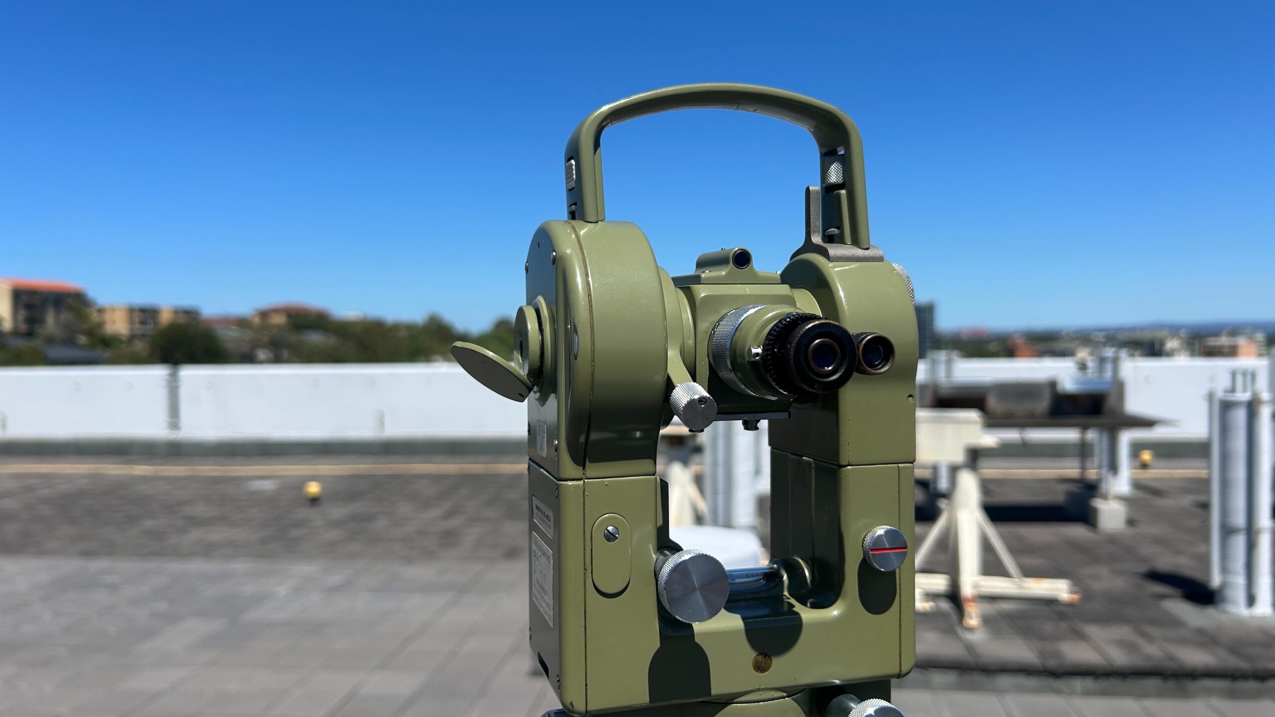
Photograph by MapStaringEnthusiast, 2025. Wikimedia Commons; CC0. Resized by WordPress.

Why surveyors turn the telescope over
Watch a careful angle observation and the operator may seem to do the same job twice. After sighting the targets, the surveyor reverses the telescope and turns the instrument to sight them again. These are observations in two faces, often called face left and face right, or face I and face II.
There is a reason for the apparent repetition. Certain small instrument errors change their effect when the telescope is reversed. Combining the two sets of observations can reduce those effects and reveal disagreement that a single reading would conceal. Repeated sets also help show how consistently the observer can point to the targets.
Technical sidebar: what reversal can and cannot fix
Horizontal collimation error arises when the line of sight is not perpendicular to the trunnion axis. A tilting-axis error occurs when that axle is not perpendicular to the standing axis. Two-face observations can cancel their effects in the mean horizontal direction; vertical index error can similarly be eliminated from a properly combined pair of vertical-circle readings.
That does not move an off-center instrument back over its station or make an incorrectly identified target correct. Nor does reversal eliminate vertical-axis tilt caused by poor leveling. Electronic compensation and stored calibration values help within their designed limits. Follow the instrument’s procedure rather than treating a second face as a universal cure.
A separate nuisance can appear right in the eyepiece. If the target image and crosshairs are not focused into the same plane, the crosshairs seem to shift against the target as you move your eye. That is parallax. Focusing the crosshairs and then the target removes an ambiguity that no beautifully engraved circle can repair.
The useful question is therefore specific: what could this check actually catch? Repeating a direction from the same displaced setup may produce excellent agreement. Observing from an independent setup or connecting to known control tests something different. The value lies in giving a mistake another opportunity to show itself.
The theodolite inside the total station
Electronic angle reading changed the observer’s job again. Encoders replaced manual reading of the circles; a display supplied the numbers. Combine that angular measurement with electronic distance measurement, or EDM, and the instrument can measure both the direction to a point and its distance. The total station brings those measurements together with computation and recording.
That combination is powerful because a direction alone leaves an entire line of possible positions. Distance places the target along that line. With a known setup position, orientation, and the necessary height information, the observations can be converted into coordinates. The arithmetic that once traveled to the office can happen beside the tripod.
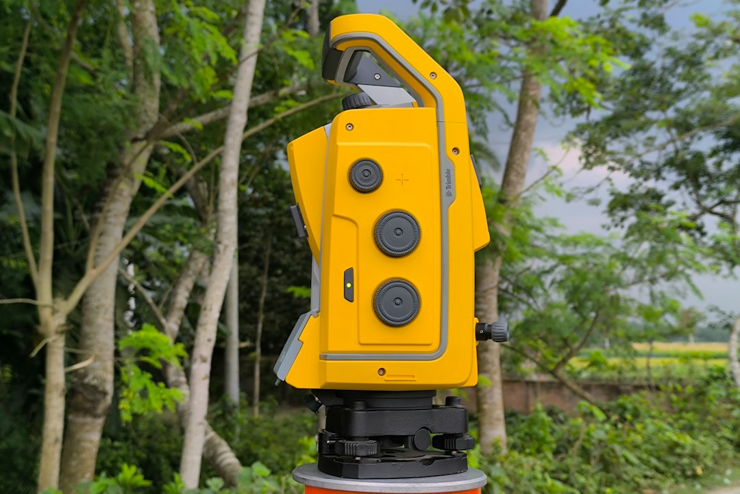
Photograph by Nasim Uddin. Original photograph; Unsplash License.
Robotic instruments add motors and target tracking, allowing the surveyor to work from the prism pole while the instrument follows. The Trimble S5 shown here is one example. Other total stations add imaging or scanning. Each development changes how much work a crew can do, while the underlying angle still depends on a line of sight and a reference direction.
Satellite positioning has given surveyors another way to establish position, but a total station remains useful wherever a visible target needs to be related precisely to nearby control: a building line, an alignment, a construction detail, or a point being watched for movement. The technology has acquired batteries, radios, and software. It still needs to know what it is looking at.
A line worth keeping
The next time you see a surveyor pause behind a telescope, the pause may contain more than an attempt to get a number. It may be a check on a reference, a comparison between two faces, or a decision to wait for a wavering target to settle. The theodolite gave surveying a remarkable ability to reach across space. Its lasting gift is that those distant directions can be brought back, recorded, and tested by someone else.
Sources and further reading
- William Ford Stanley: Surveying and Levelling Instruments. Historical maker’s account of instrument construction, circle division, transits, and optical adjustment; chapters II and VII.
- The Huntington: Pantometria (1571). Bibliographic record for Leonard and Thomas Digges’s book.
- Royal Museums Greenwich: Humfrey Cole’s theodolite, 1574. Object construction, date, and restored upper components.
- Science Museum Group: Ramsden’s 1791 theodolite. Surviving instrument and its purchase by the Board of Ordnance.
- Joseph F. Dracup / NOAA: Geodetic Surveys in the United States. Hassler’s instruments, early baselines, triangulation, and changes in instrument size.
- NOAA: Triangulation, Traverse and Horizontal Networks. How connected observations extended survey control.
- Wild Heerbrugg: T2 (T2E) manufacturer’s brochure. Optical circle reading and micrometer, in a digitized manufacturer publication.
- Karl Zeiske / Leica Geosystems: Surveying Made Easy. Angles and total stations, pp. 5–7; instrument errors, pp. 24–25. Digitized manufacturer booklet.
- Leica Geosystems: TC(R)110 User Manual. Instrument axes, setup, angle conventions, and checking and adjustment, especially pp. 11–12, 27–29, 37, and 49–54.
- Trimble: S5 robotic total station. Manufacturer description of remote operation and target tracking.