

Engineering & Infrastructure
Surveying the Panama Canal, Part 2: Control, Excavation, Locks, and the Culebra Cut
The survey control, grades, quantities, alignment, and records behind the canal’s locks, dam, and massive excavation.
On This Page
- 01 — Introduction
- 02 — Control Outside the Work
- 03 — Culebra Cut Was Not a Fixed Shape
- 04 — Railway Track Was a Moving Tool
- 05 — A Closer Look: Quantity Comes From Surfaces
- 06 — Locks Turn Large Excavation Into Close-Fitting Geometry
- 07 — The Dam Changes the Landscape Beyond Its Footprint
- 08 — The Record Has to Survive the Excavation
- 09 — Sources and Further Reading
Series: Surveying the Panama Canal
Excavation removes the very ground on which a survey begins. At Panama, a useful reference point could not simply be left in the path of a steam shovel and expected to survive. The construction survey had to carry the chosen alignment and elevations through a landscape that was being cut away, filled, flooded, and repeatedly revised.
Control Outside the Work
Construction control gives the crews repeatable references for position and height. Main marks need protection from excavation and traffic; working points can then be set where they are needed. When a stake disappears, a crew should be able to replace it from the surviving framework rather than guess from the nearest finished surface.
This is the general surveying logic behind a project of this scale. The historical photographs show the work in progress, while the canal’s records describe the changing quantities and structures. They should not be read as proof of an undocumented instrument tolerance or a particular field procedure.
Culebra Cut Was Not a Fixed Shape
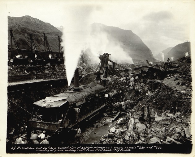
Ernest “Red” Hallen; University of Florida Digital Collections. Public domain. Source. Resized by WordPress.

At Culebra, steam shovels loaded excavated material into railroad cars. Slides repeatedly added material to the planned cut. The Canal Authority’s history distinguishes rain-related sliding from deformation caused as excavation removed support from the banks. The ground could change faster than an earlier cross section could describe it.
For surveying, the consequence is direct. A design slope is a proposed surface; a measured slope is the ground at the time of observation. Comparing successive sections shows where material has been removed or has moved back into the excavation. Keeping the dates and references consistent is essential if the comparison is to mean anything.
Railway Track Was a Moving Tool
Spoil had to leave the cut as quickly as the shovels produced it. Temporary railway alignments connected the excavation to dumping areas and changed as the working faces advanced. The railway was part of the production system, not merely the means by which workers arrived.
A working track needed usable grade and clearance, while the canal excavation followed its own final geometry. Confusing those temporary and permanent references would be costly. Construction records have to distinguish what supports the work today from what belongs in the completed project.
A Closer Look: Quantity Comes From Surfaces
Imagine two surveyed cross sections 100 feet (30.48 meters) apart. If the areas to be removed are 500 and 700 square feet (about 46 and 65 square meters), the average-end-area estimate is 600 × 100 = 60,000 cubic feet, or about 2,222 cubic yards (1,699 cubic meters). This is an illustrative calculation, not a Panama pay quantity. Irregular ground between sections, different survey dates, and material that swells after excavation all complicate a real comparison.
Locks Turn Large Excavation Into Close-Fitting Geometry
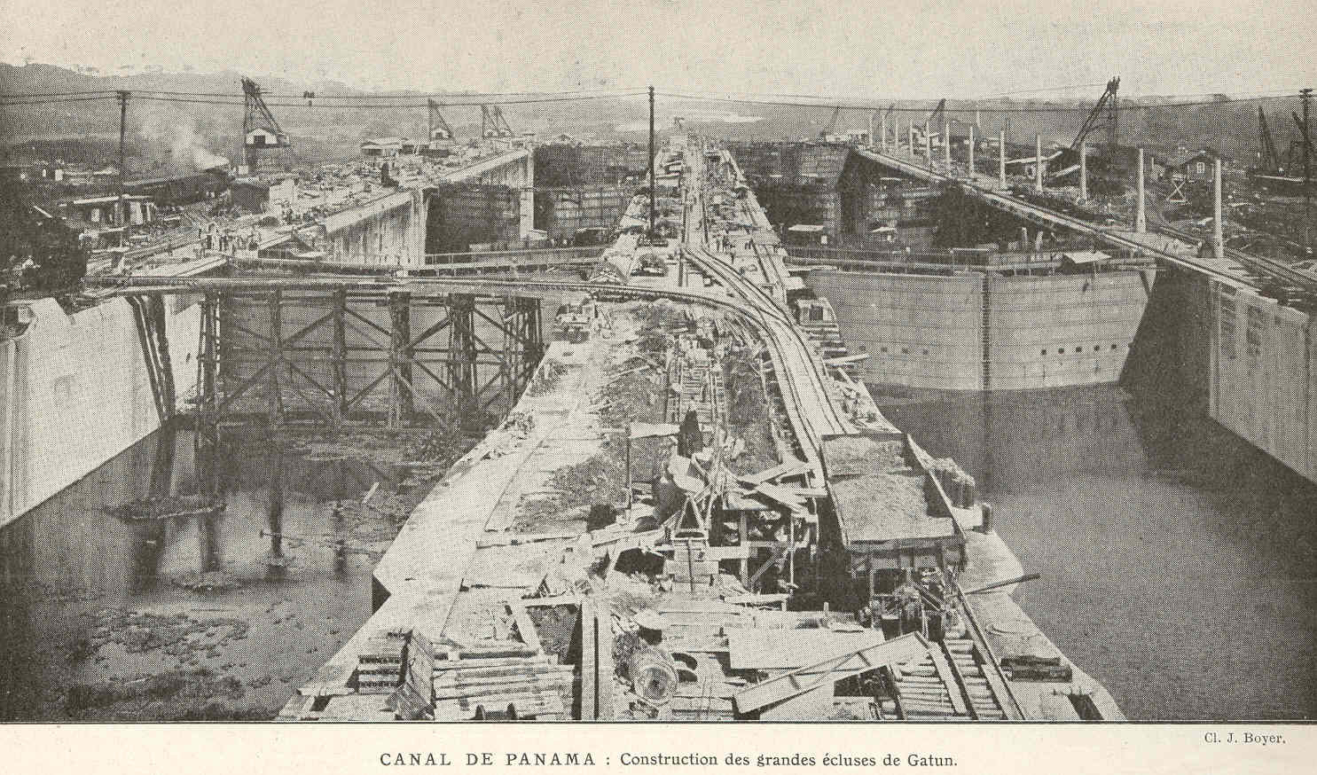
J. Boyer; Freshwater and Marine Image Bank, University of Washington. Public domain. Source. Resized by WordPress.

The original locks had usable chambers about 1,000 feet long and 110 feet wide (305 by 33.5 meters). The Canal Authority’s account of their design describes paired chambers and the culverts that move water in and out. The great concrete masses had to accommodate gates, operating equipment, and hydraulic passages whose locations related to one another.
A large overall dimension does not make every fit forgiving. Gate supports, recesses, and adjoining components depend on the intended alignment and elevation. Surveying establishes that geometry; dimensional checks and engineering inspection test whether the construction satisfies it. No single centerline stake can represent all the interfaces in a lock.
The Dam Changes the Landscape Beyond Its Footprint
Gatun Dam made the elevated lake possible. Filling a reservoir alters the meaning of nearby roads, railways, settlements, and marks: ground that could once be occupied may lie beneath water. The survey record must connect the pre-filling landscape to the finished system.
That connection also matters when someone later compares a design elevation with an operating water level. Both numbers need the same reference before their difference can describe storage, depth, or clearance. A shared datum is part of the infrastructure even though it cannot be photographed beside the dam.
The Record Has to Survive the Excavation
Progress measurements answer how much work has been done. As-built records answer what was actually constructed. Monitoring observations answer whether something has moved. They may reuse control and instruments, but they serve different decisions and should retain those identities.
The canal opened in 1914, but the landscape did not stop changing. The lasting surveying achievement was a record that could carry the project from construction into operation. The final installment follows that continuing work beneath the water, along the slopes, and through later changes to the canal.
Sources and Further Reading
Panama Canal Authority: Culebra Cut
Panama Canal Authority: Design of the Locks
Library of Congress: Opening of the Panama Canal
Library of Congress: Panoramic photographs collection, canal construction records