

Engineering & Infrastructure
Surveying the Panama Canal, Part 1: Finding a Route Between Two Oceans
How reconnaissance, maps, levels, rivers, and competing canal concepts shaped the choice of a route across Panama.
On This Page
- 01 — Introduction
- 02 — The Profile Changes the Question
- 03 — Sea-Level Cut or Lock-and-Lake Crossing
- 04 — The French Effort Left More Than Excavation
- 05 — The Chagres Becomes Part of the Route
- 06 — A Closer Look: The Water Surface and the Bottom
- 07 — The Route Extends Into Both Oceans
- 08 — Choosing What to Build
- 09 — Sources and Further Reading
Series: Surveying the Panama Canal
On a small map, Panama looks like the obvious place to cut a passage between oceans. A profile of the ground tells a more complicated story. The route crosses a continental divide and a river system that can carry enormous flows. Before anyone could estimate the excavation, the project had to answer a basic question: would ships pass through the land at sea level, or be lifted above it?
The Profile Changes the Question
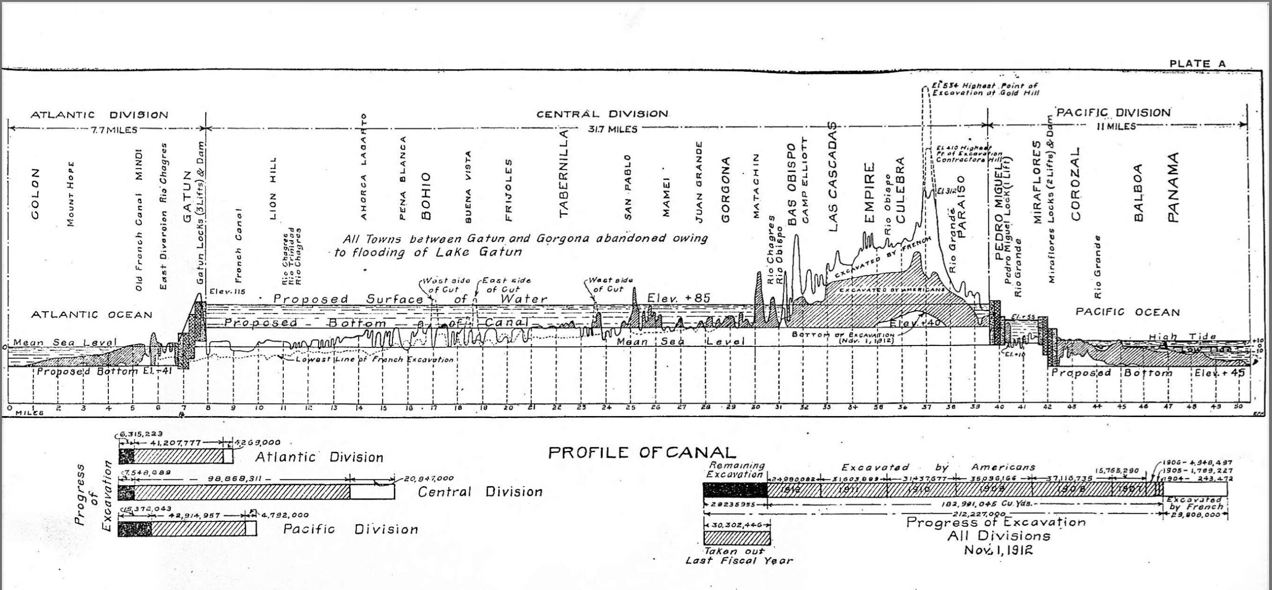
Isthmian Canal Commission. Public domain. Source. Resized by WordPress. View the larger profile.

A longitudinal profile plots elevation along a proposed route. It makes the central ridge visible as a height to be crossed or removed. Cross sections then describe the ground to either side, where the width of the cut and the angle of its slopes determine how much material must be excavated.
That is why a canal cannot be compared by length alone. A short crossing through high, unstable ground can require more work than a longer route with gentler terrain. The survey needs enough detail to compare alternatives on the same basis. Otherwise, the most attractive line may simply be the least thoroughly investigated one.
Sea-Level Cut or Lock-and-Lake Crossing
A sea-level concept aims to keep the waterway close to ocean level through the crossing. A lock canal instead raises vessels into an elevated reach and lowers them on the other side. The Panama Canal Authority’s history explains the chosen arrangement: locks lift ships to Gatun Lake, roughly 85 feet (26 meters) above sea level.
The elevated lake reduced the depth of excavation required through the divide, but it created a different set of obligations. Dams had to retain the water. Locks had to lift and lower vessels. The watershed had to supply the system. A profile could show the geometric advantage; hydrology and geology had to show whether it could work.
The French Effort Left More Than Excavation
The French project began under Ferdinand de Lesseps, whose success at Suez shaped expectations. Panama presented different terrain and water conditions, together with severe disease and financial difficulties. The later American project inherited excavation, equipment, and records from that effort. The Library of Congress history guide follows the succession of projects that led to the canal’s opening in 1914.
Inherited surveys are valuable because they preserve observations that may be costly to repeat. They still have to be evaluated: where were the marks, what elevations did the records use, and how did the earlier plan differ from the new one? Reusing a record is a technical decision, not an assumption that every line in it remains current.
The Chagres Becomes Part of the Route
The Chagres River was both a source of danger and a source of water. A canal plan had to accommodate its flow rather than treat the river as a narrow obstacle on a map. Gatun Dam impounded the valley, creating the lake that became a major part of the navigation route.
This expands the surveyor’s field of view. The centerline is only one piece of the project. Reservoir limits, tributaries, dam sites, and areas affected by changing water levels also need to be understood. A waterway’s geometry reaches into the watershed that keeps it working.
A Closer Look: The Water Surface and the Bottom
In an illustrative elevated reach, suppose the water surface is at elevation 85 feet (25.9 meters) and the channel bottom is at 45 feet (13.7 meters), both referred to the same datum. The water depth is 40 feet (12.2 meters). If the surface falls 3 feet (0.9 meter), the bottom has not changed, but the depth becomes 37 feet (11.3 meters). This simple subtraction explains why a route profile and a water-supply study cannot be separated.
The Route Extends Into Both Oceans
A canal also needs navigable approaches. Shoreline surveys, soundings, and water-level observations describe the entrances where ships meet the inland system. A depth below the water surface at one instant is not yet a charted depth unless its reference is understood.
The two ends cannot be joined by assuming that every local tide reading represents the same level. A consistent vertical framework is needed to relate the land profile, lock elevations, and approach depths. Surveying joins those different views into one project.
Choosing What to Build
The eventual canal was a chosen relationship among land, water, and machinery. Its route was not merely discovered by finding the narrowest part of the isthmus. Surveying made the alternatives measurable; engineering and political decisions determined which one would be built. The next installment follows the selected line into the cut, the locks, and the records of construction.
Sources and Further Reading
Panama Canal Authority: History of the Canal
Library of Congress: Opening of the Panama Canal